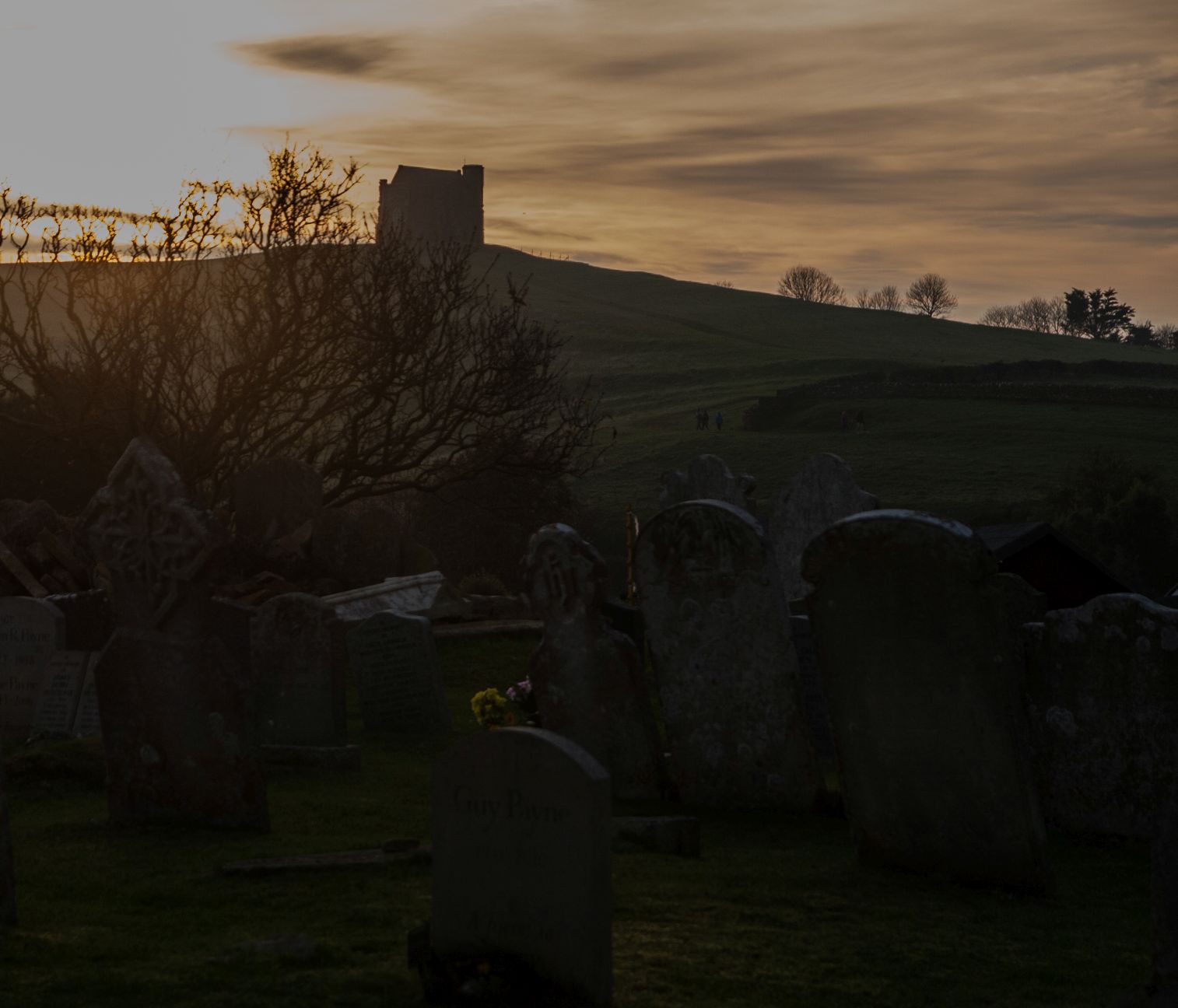
So, I'd read about this withered hand ghost in the book Paul got me a couple of birthdays ago. The picture was so big and graphic and it had gone round my head so many times that I began to imagine if anyone dared turn up in Pimperne village they were bound to see this cut off hand making its armless way down the road.
So I devised one of my circular routes with another ghost story thrown in for good measure, and set off, mentally fortified to meet the limbless spectre. Of course I was bitterly disappointed, not just by the distinct lack of anything spectral other than the fog, but by the general lack of scenery on this walk. I was just getting to the good bit when I had to turn round and come back it seemed.
Don't let this put you off, perhaps the ghost hand only appears on certain days, the 16th of December for instance. The story goes that on that date in 1780 a guy called
Blandford was a trumpeter with the Dragoons who engaged with poaching on the side. One night he was stumbled upon by a posse of gamekeepers; during the ensuring fight he lost a hand and was captured. While the hand was buried at Pimperne churchyard, Blandford recovered from his injury, and died in London a few years later. The hand is said to crawl around the graveyard and will not rest until reunited with the rest of Blandford.
Maybe I should have wandered a bit more in the churchyard - and probably come at night!
 |
| St Peter's Church and cemetery, Pimperne - ST9009 |
I walked past Stud Farm Dairy, north-eastwards along a road and then a good track and passed a few dog walkers. I just managed to step into ST9010 for a boring photo.
 |
| Ferns Plantation - ST9010 |
Hurray! I had something other than a field to look forward to in the next gridsquare. Pimperne Longbarrow. I didn't realise it at the time but this is the longest long barrow in Dorset, 106 metres (330 feet) along its axis and 27m (90 feet) wide at its broadest point and it rises to 10 feet high. The barrow can be roughly dated to 3500-4000 BC.
The long earthen mound was built to cover a communal burial site built of timber and was flanked by a set of parallel side-ditches, though these have now silted up and are very hard to make out. The shape of the barrow is parallel-sided, like a long rectangle, in common with many other Dorset barrows, unlike the tapered barrows you will see elsewhere in the south-west.
The inner burial chamber has never been fully excavated, so we don't know how many burials took place here or if people were buried with grave goods. We do know that there must have been a sizeable community nearby, as traces of huts have been found, and there are numerous burial mounds in the area. (Information from http://www.britainexpress.com/attractions.htm?attraction=3111
 |
| Pimperne Long Barrow - ST9110 |
I walked along the length of the barrow and then got a bit confused about the direction of the footpaths. It should have been footpathS, plural, but I could only see one footpath and that wasn't the right one. i intended to return on that one, but decided to just take it and hope that the footpath would be more obvious when I came to join it at the opposite end.
I looked for the earthworks in ST9111, but there were substantial crops in the field and the rest of the earthworks were in the woodland and I just wasn't tempted sufficiently to go in search of them, so hoped there would be something better to photograph on my return route for that gridsquare. (A futile hope as it turned out.)
Never mind, Sprake's buildings would surely be an attractive enough feature for the next gridsquare. I couldn't actually see the, but took a photo of a barn instead.
 |
| Barn, North Tarrant Hinton Down - ST9211 |
As is often the case, there was no external evidence of the site of a Roman building north of my footpath, so I walked past Barton Hill Dairy and then turned right onto a footpath which ran on the south bank of The Tarrant, which seemed rather a grand name for a body of water which I couldn't actually see, but I'm sure flows more fully elsewhere to make it more deserving of the definite article before its name. I wasn't too worried about this gridsquare because the northern part of the village of Tarrant Hinton is contained within ST9311, including the church where I planned to have my tea break.
 |
| Tarrant Hinton - ST9311 |
In fact, this was the most interesting feature of today's walk (potential ghosts aside).
 |
| St Mary's Church, Tarrant Hinton - ST9311 |
The church is interesting in that it was one of the last churches to have an Easter Sepulchre before the Reformation which put an end to their use.It has been dated as 1520 and is a beautiful example of Italian Renaissance architectural style. It contains the initials 'TW' for Thomas Weever (also known as Thomas Troteswell) who was the rector between 1514 and 1536, and therefore rector at the time of its construction. Although it is still damaged, it has received extensive repair works and surveillance.
 |
| The Easter Sepulchre, St Mary's Church, Tarrant Hinton - ST9311 |
The Easter Sepulchre is an arched recess generally in the north wall of the chancel, in which from Good Friday to Easter Day were deposited the crucifix and sacred elements in commemoration of Christ's burial and resurrection. It was generally only a wooden structure, which was placed in a recess or on a tomb. This was largely a Catholic practice, hence its abolition after the Reformation.
There is also a beautiful stained glass window in this church, designed and created to commemorate the millenium.
 |
| Millenium stained glass window, St Mary's Church, Tarrant Hinton - ST9311 |
The window is based on a passage from Scripture Joel 2:21 - 23:
Do not be afraid, land of Judah;
be glad and rejoice.
Surely the Lord has done great things!
22 Do not be afraid, you wild animals,
for the pastures in the wilderness are becoming green.
The trees are bearing their fruit;
the fig tree and the vine yield their riches.
23 Be glad, people of Zion,
rejoice in the Lord your God,
for he has given you the autumn rains
because he is faithful.
He sends you abundant showers,
both autumn and spring rains, as before.
24 The threshing floors will be filled with grain;
the vats will overflow with new wine and oil.
25 “I will repay you for the years the locusts have eaten-
the great locust and the young locust,
the other locusts and the locust swarm -
my great army that I sent among you.
26 You will have plenty to eat, until you are full,
and you will praise the name of the Lord your God,
who has worked wonders for you;
never again will my people be shamed.
27 Then you will know that I am in Israel,
that I am the Lord your God,
and that there is no other;
never again will my people be shamed.
Funny, as I'm typing this having just watched 'Planet Earth 2' about the deserts and the plague of locusts!
I left the church pondering Easter sepulchres and locusts and continued my walk for a short while along the busy road between Tarrant Hinton and Tarrant Gunville. Thankfully, this was only for a very short section, but long enough to pass an old, redundant petrol pump.
 |
Old petrol pump, Tarrant Hinton - ST9311
|
I now wandered across Tarrant Hinton Down, which is actually further north than North Tarrant Hinton Down and there really is very little to see. I mused on the meaning of Ninety-nine plantation as I walked past, looked for a second long barrow near Chettle, and then looked for Chettle House.
 |
| Footpath across Tarrant Hinton Down - ST9411 |
 |
| Ninety-nine plantation - ST9412 |
Chettle House was totally covered in scaffolding and some sort of covering which rendered it invisible to the passer-by. The mud was totally visible though as the heavy plants had churned the footpath up during renovation work. A long-haired man on a phone apologised for the mud as I passed by and I wondered if he were the owner. Glad that I didn't have to walk through the field with the cows, I turned right towards Chettle Church and immediately realised I would later have to walk the cow field.
 |
| Chettle Church - ST9513 |
I was disappointed to find Chettle Church locked so quickly retraced mysteps to the cow field, retrieved my pole from its stowed position and bravely marched across the field, which is actually The Park.
 |
The Park, Chettle - ST9413
|
This turned out to be the most scenic part of the walk, and would have been particularly attractive in summer or early autumn. With most of the trees now having lost their leaves, it looked quite drab, but there was still a little colour to brighten the day, especially when I reached Little Wood, where a gate's signage made me smile.
 |
| Sign on gate at Little Wood - ST9412 |
 |
| Chettle Park - ST9412 |
 |
| Little Wood - ST9412 |
Eastbury Park, the subject of another ghost story in this area sits bang in the middle of ST9312 and I hoped for more than a partially obscured glance at this ghostly place. From the north-east corner of the square I could only see what looked like a keeper's cottage; I hoped for more when I walked west of the property.
 |
| Eastbury Park - ST9312 |
Once out of Little Woods, I marched through another boring field to find Chettle Long Barrow.
 |
| Chettle Barrow - ST9313 |
I then walked past Solomon's Quarters and was intrigued by a symmetrical row of two dots on the OS map. What could these be? I asked myself. It turns out they really are tumuli -just really symmetriclly placed ones.
 |
| Tumuli at Solomon's Quarters - ST9313 |
Another thing I was wanting to see was Zareba Clump, a circular shaped clump of trees. I'm drawn to anything and any place beginning with the letter 'z' as I feel it is not used enough in our language. There was nothing particular of note about this clump of trees, except for its unusual name.
 |
| Zareba Clump - ST9313 |
It was a straight forward walk now to Tarrant Gunville, where my second ghost story took place. Sadly I didn't get much more than a distant and obscured glimpse of Eastbury House, where these grisly events took place.
Eastbury House was once owned by George Bubb Doddington, the Second Earl Temple. Whilst based in his Italian retreat in 1795, Doddington sent an instruction to his steward, William Doggett, to dismantle the wings of Eastbury House. Doggett thought that his master would not return from Italy and decided to take the opportunity to profit from Eastbury. He had the main house and the South wing dismantled, sold the materials and stole the money. The materials were used in the construction of several other buildings including the rectory at Tarrant Gunville, Ashmore Manor and Bryanstone House. When Doggett learned that his master was returning from Italy unexpectedly and that he had no time to cover his crime, he committed suicide by shooting himself.
After his suicide on 23 June 1786 it is said that a bloodstain was left on the marble floor which could not be cleaned. In his 1975 book "The Vampire's Bedside Companion" Peter Underwood says that doors would start to open by themselves and that an apparition was seen, "Doggett's ghost was seen, his face a mass of blood." He goes on to say "Then, in 1845, during the rebuilding of the church and reorganisation of the churchyard, Doggett's corpse was exhumed. When the coffin was opened the legs of the body were found tied together with yellow ribbon but, more frightening, the body was not in the least bit decomposed; in fact the face had a rosy complexion, although the course of the bullet that had killed him, from the jaw through the head, was clearly visible. Now the secret was out and after the 'vampire' was dealt with in the accepted way, there was no further trouble and there were no more reports of Doggett's bloodstained ghost."
According to "Haunted Houses - Tales of the supernatural with some accounts of hereditary curses and family legends", by Charles G. Harper, 1907. "It is the ghost of Doggett, the fraudulent steward of that Earl Temple, which haunts the road and the long drive up from the park gates to the house. The neighbourhood knows Doggett very well indeed, and can tell you how, emulating the vaster frauds of him who built the place, he robbed his employer and oppressed the tenantry, and at last shot himself. Generally at the stroke of midnight, a coach with headless coachman and headless horses drives out and picks up Doggett, down the road."
"If you see an old-world figure at such a time, stepping into that horrid conveyance, you will recognise him as Doggett by his knee-breeches, tied with yellow silk ribbon. The headless coachman asks (out of his neck ?), "Where to, sir ?" and the ghost says, "Home"; whereupon the horses are whipped up, and they drive back to the house. The shade of Doggett, entering, proceeds to the panelled room where he shot himself a century and a half ago - and shoots himself again !"
"Doggett was buried in the neighbouring church of Tarrant Gunville. That building was demolished and rebuilt in 1845, when the workmen, exhuming his body, found the legs to have been tied together with yellow silk ribbon. The material was as fresh and bright as the day it had been tied, and the body was not decayed. The credulous country folk averred that he was a vampire.”
A grisly tale indeed! I was keen to get to the church and see this vampire! Needless to say, there was neither sight nor sound of Doggert at the church or on the quiet lanes of Tarrant Gunville. The only people I met were two young lads weed-killing the graveyard.
 |
| Sign on a cottage, Tarrant Gunville - ST9212 |
I was glad to sit and eat my late lunch in the church. There is a memorial here to Thomas Wedgwood, who also lived at Eastbury House and who was the third son of the famous 'Wedgwood' potter.
 |
| Inside St Mary's Church, Tarrant Gunville - ST9212 |
 |
| Memorial to Thomas Wedgwood, St Mary's Church, Tarrant Gunville - ST9212 |
I was on the homeward stretch now, and glad of it. A sign for Home Farm's Farm Shop and cafe drew my attention. It said it was closed on Mondays and Tuesdays, but open throughout the year otherwise. Surely this couldn't be true? Surely it wouldn't be open on a cold late November afternoon? Surely it could! Yippee!! More eager to use the cafe's toilet facilities than for a cup of tea and managing to resist the tempting array of cakes on display, I sat down in the warmth and then perused the wide selection of goodies on offer. I chose a bottle of local cider as a present for Paul's son who would be coming for tea that afternoon. I was glad now that this was at the end of my walk, rather than at the beginning as originally planned. At least I didn't have far to carry the extra weight now!
 |
| Home Farm Farm Shop - ST9112 |
 |
| Attractive ruin at Home Farm - ST9112 |
having saved the last gridsquare's photo until my return journey, I wished I'd persevered in looking for the earthworks. There really was nothing to photograph in the square, but photograph it I must - and did!
 |
| Hinton Bushes - ST9111 |
I felt vindicated in my earlier choice of footpath as the footpath shown on the map does not go through the above ploughed field as shown, but follows the edge of the field so was not obvious when I approached it earlier. I had made the right choice.
There was no choice now but to retrace my steps of earlier in the day, a monotonous path before, and certainly not worth repeating, but i'd learned a lot of things en route and bagged a few squares at the same time and found a delicious coffee shop.
Number of miles walked: 11.2
Number of new gridsquares: 14
Number of people I spoke to today: 8
Number of cows I spoke to today: 0
Number of churches: 4 (only 3 open)
Number of old petrol pumps: 1
Number of ghosts seen: 0