Newly motivated after my decision to 'cut the county in half', I sat down on the evening before my day off and indulged in one of my favourite pastimes - pouring over the Dorset map to look for big blank bits. How come there was a gaping white area that close to home? Hmmm. Now if I draw a line from there to there and then to there . . . . I end up with a 10 mile walk, which is just about nice.
Duly I set off ever so early (another one of my favourite things) for Coney's Castle - without the aid of the sat nav. No, I didn't need that. I knew exactly where I was going - or I thought I did. Why do I never learn? Half an hour later I was convinced I'd taken a wrong turn (I had) and trying to find somewhere to pull in to check my map (there was nowhere). The trouble lay in a hotch potch of roads just north of Coney's Castle called Peter's Gore. Intrigued, I googled this and discovered that a gore derives from Old English 'gara' which is a triangular piece of land where roads meet. I guess this bit of triangle belonged to a chap called Peter, who incidentally, could have done a better job of road planning if you ask me. I mean, there's a plethora of junctions there which is just plain confusing.
I walked down Long Lane on the Wessex Ridgeway towards the sea and Charmouth, looking for the continuation of the Wessex Ridgeway to the right.
 |
| Long Lane - view towards Charmouth - SY3797 |
Going through a gate I spied a herd of Friesian cattle some way to my right; I was heading left so I was OK, and I was walking towards the sea - always an exciting prospect.
Through another gate and into probably one of my worst types of habitat - a field of maize. It totally blocks your view and nothing lives there and it's difficult to walk through. Still, there was a glorious patch of Redshank just before it.
 |
| Field of Redshank and maize on the Wessex Ridgeway - SY3796 |
 |
| Redshank Field - SY3796 |
I emerged from the claustrophobic horror of the maize to be greeted by an unmistakable bovine sound. The cattle must have been watching my flailing movements through the crops for some time as they were all at the gate of the next field awaiting my entry! I don't think they'd seen another human emerge from that field this year!
 |
| Cattle awaiting my entry into 'their' territory - SY3796 |
After grappling with a single ear of corn to use as a 'stick' (my proper pole still being in the boot of Paul's car), and armed with bravado, I crossed the stile to face my enemy. I deployed my 'I'm bigger than you are' weapon and hoped no-one was looking (fat chance) as I waved and shouted my way across the field to the next gate.
Oooh, I had the bonus of steeping briefly into SY3696 - just enough to get a photo of a non-descriptive field.
 |
| Field near Wootton Fitzpaine - SY3696 |
The Wessex Ridgeway joins forces with the Liberty Trail here and I left both and entered a local footpath, a green lane down to the delightful village of Wootton Fitzpaine.
Various signs direct you to the church, making sure you don't enter the wolf guarded East Lodge Estate instead.
 |
| A sort of wolf adornment to the gatepost of East Lodge, Wootton Fitzpaine - SY3795 |
 |
| Sign to the Church - SY3795 |
 |
| Sign to the church, Wootton Fitzpaine - SY3795 |
I adore finding these hidden gems of churches. I know their original purpose was not to be hidden (Jesus after all talks about not hiding your light under a bushel) and, at one time, everyone in the village and surrounding farms would have attended church every Sunday. Sadly those days are gone and I wonder how many people now attend. For me, these buildings are still very much a sanctuary. They are a sanctuary for wildlife too as they are often maintained as wild churchyards deliberately for the wildlife. But they are also so tranquil and beautiful and conducive for meditation or prayer, whether inside the building or out.
 |
| Wootton Fitzpaine Church (no dedication) - SY3795 |
 |
| Wild graveyard - Wootton Fitzpaine - SY3795 |
 |
| Wootton House - SY3795 |
Inside the church there is a comprehensive display illustrating the history of the village in old photos and text and it is well worth lingering to study the photos and try to imagine what life must have been like here a century ago when there was still a blacksmith in the village and when people regularly attended church. It's also worth looking for an unusual subject in the big stained glass window which faces you when you enter the church - a pelican. I'm not sure why it's there, but it is, complete with a nestful of pelicanettes!
 |
| Pelican in stained glass window (in circle), Wootton Fitzpaine Church - SY3795 |
Deciding I was going to get a geocache en route as well I walked along Wootton Lane rather than the footpath. Evidently photographing every gridsquare, every gate (for yet another project) and recording every butterfly as well as simply enjoying the walk wasn't enough for one day.
After grabbing the cache, I proceeded across fields to Green Pit Knap, a road that is not marked as such on the Ordnance Survey map, but is on the satellite software I use. I crossed the road and walked across more fields before joining the Monarch's Way to Charmouth.
 |
| Fields near Green Pit Knap - SY3695 |
Several fields, gates and footbridges later, I arrived at the A35.
 |
| Footbridge over River Char tributary on Monarch's Way near Charmouth - SY3694 |
I was glad to discover that the footpath went underneath the busy dual carriageway (I wonder if it did in King Charles' day when he was fleeing the parliamentarians!)
I was now in tourist country, but resisted the sign for the beach (and the bakery), turning right instead to go to St Andrew's Church where I knew there was at least one interesting grave. Would I find it alright though in such a conglomeration of old gravestones?
 |
| St Andrew's Church, Charmouth - SY3693 |
I needn't have worried. The grave in question is staring you in the face as you approach the church, but I guess you would walk right past it unless you knew it was there.
 |
| James Warden's tombstone, St Andrew's Church, Charmouth - SY3693 |
The story of the duel is an interesting one. It took place in 1792 between James Warden and Norman Bond, two neighbours who had been out shooting together. They disagreed about who had shot a particular partridge and exchanged some strong words. An argument ensued in which Warden became extremely abusive and threatened to shoot Bond's dogs. Bond demanded Warden apologise, Warden refused, and so Bond challenged Warden to a duel. The time and place was quickly set, the duellers would meet at Hunters' Lodge on the morning of 28 April 1792.
Allegedly Warden's wife, Elizabeth, not only did not oppose the duel, but supplied the guns for the event. The day of the duel arrived. As Bond had issued the challenge, Warden took the first shot. Bond had a narrow escape as the ball passed straight through his hat. Bond now took his shot - Warden fell to the ground. He had been shot through the heart and died almost instantly. Bond was charged with murder and fled the country. Despite not doing anything to stop the duel Elizabeth was apparently heartbroken at the death of her husband and had a verse composed by a man from Lyme Regis which was inscribed on the tomb and I think is now illegible. Part of it reads:
Dear victim of imperious honour's lawsThese imperious laws inexorably sternWhose honour friendship views with shuddering pauseAnd love conubial shall for ever mournAdieu! in one alarming moment tornBy ruffian rage, from her thy soul held dear . . .
 |
| Inscription on james Warden's tombstone, St Andrew's Church, Charmouth - SY3693 |
Amongst other interesting memorials and graves here are a memorial to Palmers (of brewery fame, Bridport) and the grave of Ann Pitts, who was thrown off a stage coach in 1805. She had been travelling from Exeter to London to visit a relation but the stage coach overturned on Charmouth Hill, and Ann Pitts, who was sitting outside was thrown onto the road with such force that she died immediately. She was 58 years of age. I couldn't find her gravestone as there are many illegible ones leaning against the wall and they are mostly illegible. I shall have to return to look harder! And for other interesting ones too, but if I were to tell all their stories I'd never finish this blog!
 |
| Memorial to Edmund Palmer (of Palmer's brewery fame), St Andrew's Church, Charmouth -SY3693 |
 |
| Graves leaning against the wall, St Andrew's churchyard, Charmouth - SY3693 |
After chatting to the flower arranger whose family have been buried int he graveyard for generations, I left reluctantly. There was so much of interest here and I wanted to linger, but then I wouldn't have finished my walk.
I retraced my steps (resisting the bakery for the second time) to the A35 and went under the tunnel once more. Immediately I turned right towards Catherston and found myself in woodland with dappled sunlight - delightful!I crossed a tributary of the River Char and headed northeast up a field to Catherston. Although not marked as a camp site on the map, there were several tents pitched here and holiday makers slowly dissembling their tents. I bade them good morning and continued to the minor road where two great stone pillars greeted me. I hadn't thought I'd be able to visit the little church on this private estate, but a little sign pointed to St Mary's Church and so I walked along the private road and found the diminutive building bathed in sunlight and locked. At least I thought it was. I've since read that it is open daily, so maybe I didn't push hard enough. There is quite a lot of information online about this church:
http://www.goldencapteamofchurches.org.uk/stmarycatherstonhistory.html
 |
| St Mary's Church, Catherston - SY3694 |
One interesting fact is that it is one of only two churches in Dorset that the Victorians built using oak for the roof and pews. The other church is in Frampton.
Leaving the church I began to think about where I could have lunch. There had been a bench in the churchyard, but I would have been overlooked by two men in a transit van so I decided to continue north-eastwards towards Conegar Hill.
There was a horse in the next field, struggling with flies, but otherwise docile. I waited until i was on the other side of the gate before succumbing to its pleas for affection.
 |
| Horse and view of Charmouth - SY3694 |
 |
| Charmouth from Catherston - SY3694 |
I was beginning to feel that I would never get out of this gridsquare, but the next one was just as interesting. I was climbing quite high now and getting wonderful views of not just the sea, but inland westwards, the direction I'd walked from.
 |
| An 'old lady' tree root - SY3794 |
 |
| Tree roots above Catherston and Charmouth on lower slopes of Conegar Hill - SY3794 |
 |
| Tree roots above Catherston and Charmouth on lower slopes of Conegar Hill - SY3794 |
 |
| Above Catherston and Charmouth on lower slopes of Conegar Hill - SY3794 |
 |
| Tree roots above Catherston and Charmouth on lower slopes of Conegar Hill - SY3794 |
Wow! I was loving this and could have stayed here longer just photographing the trees' amazing roots. My heart was singing and it felt so good to be alive and alone with the clouds and the ancient roots, rooted to the ground, the earth and to life.
But move on I must, so I walked through a gate and uphill again where I found a convenient tree branch to sit and have lunch.
Conegar Hill was now in view.
 |
| Conegar Hill - SY3794 |
I could also see from whence I'd come and whence I must shortly return - Coney's Castle -
 |
| Coney's Castle from Conegar Hill - SY3794 |
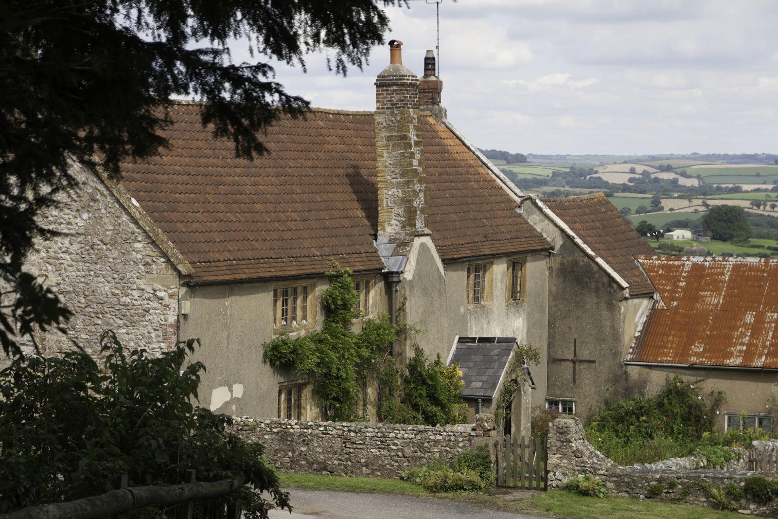
and Wootton House and church nestling in the leafy trees.
 |
| Wootton House and Wootton Fitzpaine Church - SY3794 |
At the foot of Conegar Hill proper there is a surprising little garden, a memorial garden perhaps.
 |
| Memorial garden at foot of Conegar Hill - SY3795 |
Conegar Hill is a small area of mixed woodland owned by the Woodland Trust. The bridleway runs round the east side of the woods and provides excellent views eastwards.
 |
| Bridleway, Conegar Hill - SY3895 |
It emerges at Baker's Cross where a sign misspells Marshwood as Marswood, but I guessed I was heading in the right direction!
 |
| Sign to Marswood - SY3795 |
I walked down the minor road, passing the attractive entrance to Lower Abbotts Wootton Farm, which along with its neighbour, Higher Abbotts Wootton Farm, is a bit of a mouthful!
 |
| Entrance to Lower Abbotts Wootton Farm with guardian abbot - SY3796 |
 |
| Higher Abbotts Wootton Farm - SY3796 |
At HAWF I turned onto another bridleway which started off as a veritable track and headed north-eastwards to Prime Coppices and Prime Lane. It was to be a tough mile.
 |
| Bridleway to Prime Lane near Higher Abbotts Wootton Farm - SY3896 |
 |
| Difficult walking in Prime Coppices - SY3896 |
My heart sank when I arrived at a gate which bore the bad news that there was no bridge over the river ahead. I'd come too far to turn back now so I decided to risk it, wondering whether anyone had ever walked this way before. Evidently they had, judging from the number of footprints and extent of mud on the path - also from the alternative 'path' which walkers had used and for which I was grateful, saving me a tiny bit of extra mud. Despite its remoteness and relative inaccessibility, this woodland is evidently still used for coppicing. I passed a woodshed and lots of coppiced hazel branches.
 |
| Muddy path in Prime Coppices - SY3897 |
I was glad to finally emerge at Prime Lane, and even gladder to discover that, far from there not being a bridge, there was brand new bridge.
I turned westwards now and negotiated some pretty ropey gates, wondering how anyone on horseback would cope with them. Then it was northwards to Harper's Barn, which made an ttractive photographic subject.
 |
| Harper's Barn - SY3897 |
I walked under the pylons, a common feature on my walks, sadly. These great monsters seemed to be defiantly marching across the land, their steel arms bent at the elbows. If I thought the last part of the walk was going to be any easier, I was mistaken. I turned onto a footpath, heading north-west to Baber's Farm and entered a beautiful meadow, full of butterflies, but also full of bog and thick vegetation. I wasn't at all certain where the footpath went so was glad of my memory map facility on my phone which kept me right. After nearly falling over and negotiating nettles, bog, thistles and horsetail, I caught grateful sight of the exit - peeping through the grass.
 |
| Beautiful meadow - SY3898 |
 |
| My exit peeps through the grass - SY3898 |
 |
| Through which I walked - SY3898 |
Surely it would be easier now, I told myself as I pulled my last limb through the gate and plodded northwards to Baber's Farm.
 |
| Baber's Farm - SY3898 |
 |
| An interesting sign at Baber's Farm - SY3898 |
I like seeing unusual and homemade signs - and this one made me chuckle. I continued northwards, heartened by the sight of prominent Marshwood Church, my final church of the day. Passing another farm and a purple bus, I ascended steeply to the church which is on a very busy road and which I won't do again in a hurry.
 |
| Harmshay Farm - SY3898 |
 |
| View of Harmshay Farm and Marshwood Church - SY3898 |
 |
| Old bus at Harmshay Farm - SY3898 |
St Mary's Church, Marshwood is also used by the neighbouring school, an idea which I applaud.
 |
| St Mary's Church, Marshwood - SY3898 |
 |
| St Mary's Churchyard, Marshwood - SY3898 |
I was tempted to sit outside and bask in the sun and drink in the view from here, but I had an appointment later in the day and time was running out. I retraced my steps back to Harmshay Farm and then turned right along Nash Lane, a green lane which led through another new gridsquare, to Nash Farm, the road and back to my car. An absolutely delightful walk, full of interest and beauty.
 |
| Nash Lane - SY3799 |
 |
| Nash Farm - SY3798 |
Number of new gridsquares - 15
Number of churches - 4
Number of gates - 29
Number of stiles - 5
Number of miles - 11.6


No comments:
Post a Comment