Showing posts with label Chilcombe. Show all posts

Thursday, 30 November 2017

The Land of the Fairies - Litton Cheney to Askerswell circular - 11.2 miles, 25th November 2017


This may well be the longest walk I've done for the shortest return! By 'return' I mean how many new gridsquares I gained. It reminds me a little of my 14 mile walk on Islay for the sake of two miles of coastline which I needed to walk to 'join up the gap'. Except that this was a much easier walk and did not involve an overnight stay, otters, gamekeepers and free trout!

Jane was able to join us for the day and what a day it was; my absolutely favourite, the sort which continues to bless us now - cold, frosty, crisp, clear . . . My hips were still a bit achy from my dance, but I wasn't going to let that or anything else bother me today. We wanted to reccy this walk for a group walk in December. It is almost identical to one I did in August when I did bag some new gridsquares. This was a repeat with a small change so I won't include photos of all the gridsquares this time.

We parked on the road by the White Horse which extended the walk a few hundred yards as we walked back to the church with its backdrop of serenely blue sky.
St Mary's Church, Litton Cheney - SY5590
The same photo in the summer has more green, but less blue!


We walked the same route across fields to Long Bredy where we popped into the church for an early cup of tea and were briefly joined by some other ramblers who we discovered had walked down the bridleway on the east side of Long Barrow Hill. They didn't actually say ,"we walked down the bridleway on the east side of Long Barrow Hill." They said, "yes," when Paul asked them if they were the two figures he'd seen walking down that way. Then they said they'd walked past this church many times before, but had never been inside. We agreed it was a beautiful church, but I think it is lamentable that so many people, even walkers, do not pause to visit more historic sites, especially when they're right on their doorstep. I can afford to be smug here, of course, because I always do! "Why aren't we doing that?" Paul questioned when we were back outside. "Doing what?" I queried, "Walking round the other side of the hill," he muttered, craning his head as if to exaggerate his opinion that the other way was bound the better. Honestly, there's no pleasing some people! I promised him we would when we did this walk 'for real' with the group. I'm guilty of the same thing though, always imagining that the grass is greener on the other side; choosing to go down one route and then bemoaning the fact I haven't chosen the other route - a bit like Robert Frost's wonderful poem, The Road Not Taken.

St Peter's Church, Long Bredy - SY5790
There was no cattle in the fields this time as we ascended Long Barrow Hill, for which we were grateful as it is quite a slog up there. Last time I had to go via the more gradual route but my heart was still pounding with fear when I couldn't see the huge bull and wondered if he might just be abot to thunder across the field towards me!

We were walking more or less parallel to  Long Bredy Hut Lane which we'd driven down earlier without realising that was its name. I wonder how it got its name? I googled it, but couldn't find anything out. From here we could see the sea - always an exciting sight!

Shipton Hill from Long Barrow Hill - SY5790
We crossed the busy A35 and went straight down a bridleway, past tumuli and North Barn Farm. We were amused by the electronic gate opening system which invited you to 'Press to Open' but we guessed it was for vehicular use only and opted to use the pedestrian gate instead.

It's a pleasant walk along a farm lane to a crossroads here which threw me momentarily as there was a big digger parked at our crossroads. We managed to get round the digger and onto another path open to all traffic before reaching the minor 'yellow' road at which I'd decided we would turn left and then right to avoid walking up the long straight stretch of road I'd used last time.

This turned out to be a mistake as it was hard going walking through a huge field of flint and we thought it would be inappropriate to bring a large group here so next time we'll just have to put up with the road. The views are amazing though and I realised that, although SY5592 wasn't a new gridsquare for me, I'd somehow failed to get a photo of it last time, so I was going to bag two new squares on this visit. Yippee!

Haydon Down - SY5592

Walking across flinty fields at Haydon Down - SY5592
 We could see across acres of hills and valleys to Golden Cap and the glimmering sea beyond, marred only by that ubiquitous pylonic eyesore. In days of yore this would have been a marvel to behold.

Paul was getting hungry and a little grumpy (the two go together). We promised him an early lunch spot as soon as we could find somewhere suitable to sit. "Yonder barn is our next landmark," I whispered to Jane out of Paul's earshot. "I'm not sure we'll find anywhere out of the wind before then." By the time we reached said barn (Two Gates) we didn't care about being out of the wind; we just wanted our lunch so we chose  seat with a view (not difficult) and munched on cheese rolls and gulped hot tea.

From Two Gates - SY5493

Haydown Down near Two Gates - SY5492
Fortified, we stood up to move onwards, but not upwards, "we're heading downhill!" I cheered, leading the way confidently across the plateau of Haydon Down. It wasn't long before I realised my desire to go downhill had led us prematurely down the wrong side of the hill, or at least we were heading that way. Naturally I quickly realised and bumped us along further left, keen to remain on the bridleway. On the lee side of the hill we found a path which led all the way down to Stancombe Farm and beyond to Naller's Farm. We wondered at how anyone could live this far down in the valley. I'd commented on how, despite the feeling of remoteness here, we had been constantly ale to see and hear traffic throughout our walk thus far. The A35 is never far away, but unless you wanted to get to these farms you'd never know they were there and we wondered what the tracks were like in the winter. I imagine, perhaps wrongly, that folk that live in these farms lead solitary lives, deliberately choosing to be far away from other people, but I suspect I am wrong. I hazard to guess that mostly the farm has been passed down from one generation to the next and there has been little choice in the matter. In days of yore of course the huge acreage covered by just a few farms would have been divided up into many more fields belonging or tenanted by many more farmers. Such were the days of Corncrakes and Skylarks galore, sadly now either gone forever from these corners or in serious decline.

Lane to Stancombe Farm - SY5492

Stancombe Farm - SY492

Fencepost at Stancombe Farm - SY5492

Such was our discussion as we plodded down the lane, glad to now be on more even terra firma. A rustling and movement caught our attention as we walked into the farmyard and a man's head appeared behind some rusty machinery. "We didn't see you there," Jane laughed as we bade the farmer a good morning.  He bade us a silent greeting, almost imperceptibly nodding his head in our  direction, as if to confirm my suspicions that the residents here are self-elected recluses. We hurriedly glanced at the map to decided which footpath we needed to be on, feeling the glare of the farmer who probably wasn't used to seeing many walkers in his farmyard. One track leads south to the A35 which is obviously the most direct (and probably only) road to Stancombe Farm. "We're heading west," I declared, explaining that my route had an almost phallic appearance drawn out on the Ordnance Survey map and that we were 'now leaving the phallus', "but entering the new gridsquare," I said, injecting as much excitement as I possibly could into my voice in the hope of it brushing off onto my fellow walkers. They didn't seem as excited as I'd hoped, but then I'm used to that!

It took us a bit longer than necessary to get to Naller's Farm on account of all the interesting rusting machinery left lying about and the splendid examples of strip lynchets now languishing in November apricity, sadly redundant.

Walking towards Naller's Farm - SY5492
Strip lynchets at Naller's Farm - SY5492

Rusty wheel at Naller's Farm - SY5492
Really, there is a lot to be seen and admired here and it is sad that probably very few feet wander this far into contour lines to do so. On guard duty at Naller's Farm were some rather scary stone creatures on the wall.

Gargoyle guards at Naller's Farm - SY5492
We then crossed a spring, a magical spring appearing from nowhere and disappearing into the hills, frequented no doubt by fairies and elfin creatures as we were evidently in their territory.
Fairy spring at Naller's Farm - SY5492

Here also be hedge layers and more relics of days gone by.

Hedge laying at Naller's Farm - SY5492

Left to rust - SY5492
We were now not far from Askerswell and passed fields with horses. I took photos of all of them in case one belonged to our friend who keeps her horse here. I tried calling its name but there was no response, although my call was a bit feeble as I was a little fearful of calling too loud in case Magic came galloping across the field towards us!

Horses at Askerswell - SY5392
My offer of another stop at Askerswell Church was rejected on the grounds of it getting late and we were only just going to make it back before dark as it was. So we plodded on through this delightful village, pausing only to ponder the logic behind a weird crossroads where one road abruptly ends.
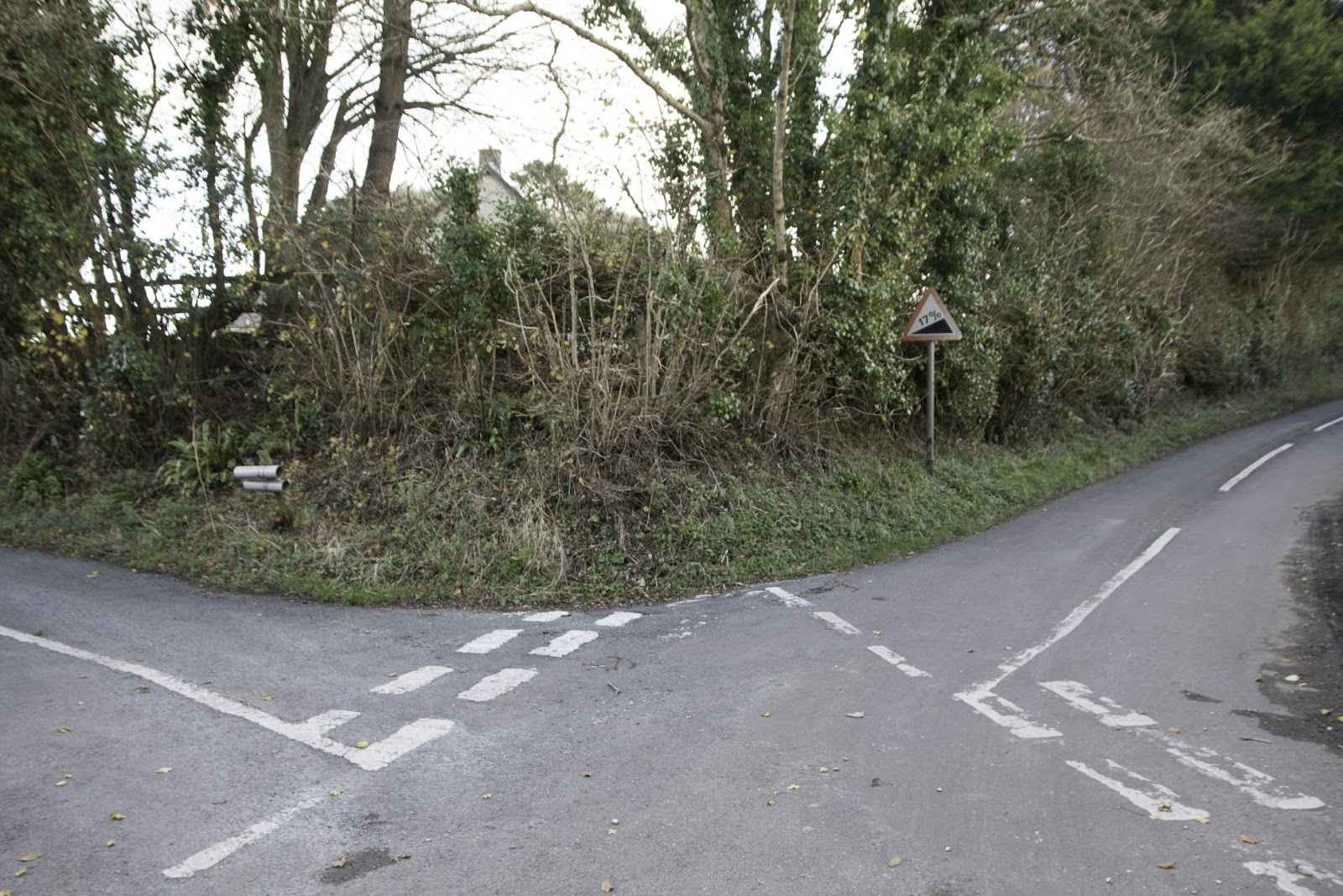

Confusing junction at Askerswell - SY5392

 I couldn't resist photographing some skeletal trees and admired the inosculation between branches of one particular tree.

Inosculation at Askerswell - SY5392

Trees at Askerswell - SY5392
We now had to negotiate a little bit of bog and probably the most unpleasant part of the walk - a steep climb to the A35. "But it's quickly over," I promised as we headed towards the traffic's deafening roar. There is no lead up to this 'mare' (Paul's son's term for 'nightmare'); you puff and pant your way up several contours to meet the ugly grey crash barrier, teeter on the side of the hill whilst waiting for a break in the traffic sufficient to get you half way across and then stand tall with your high vis jacket on waiting to sprint across the second half of the death-defying A35. If that hasn't put you offf this walk, nothing will!

Immediately on the other side you are rewarded with more glorious views. You can now ascend if you wish to Chilcombe Hill Fort and don imaginary weaponry and clothing of Iron Age times. We didn't, being well and truly in the present moment, muddy step by muddy step and bramble by bramble as we squelched our way through the thickest mud of the walk yet. I reminded my companions that 'this was nothing' compared to the mud of my walk only two days before. Eventually I had to concede it was in fact 'something' and enough to warrant revising the route, albeit only ever so slightly, in order to avoid the mud.

From Chilcombe Hill - SY5292

Shipton Hill and tumuli - SY5292

Cloudscape over Shipton Hill - SY5291
Finding the road into the hamlet of Chilcombe, we marched on past a sign inviting visitors to 'please park here' although the rest of the sign is now illegible. Fairies at work again?

Please Park Here, Chilcombe - SY5291
We descended into civilisation and the 12th Century as we paused to enter diminutive Chilcombe Church, one of my favourites. Apparently it never was any bigger, the community never having either diminished or grown over the years, though the churchyard once extended more visibly.

Chilcombe Church - SY5491

 There are always free range hens strutting around here which are a delight to see and the churchyard gate is consequently always left open.

Free-range Chilcombe hen - SY5491

We continued now without stopping back to Litton Cheney, still admiring the views and marvelling at our wonderful walk. We opted to take the footpath to the pub across the fields which has probably been in use for hundreds of years. At the White Horse we joined the vociferous locals by the fire and raised a cup of tea in celebration of a fabulous walk.

Number of new gridsquares: 2
Number of miles:11.2
Number of churches: 4
Number of contours: innumerable

Saturday, 19 August 2017

Litton Cheney to Askerswell - 17th August 2017

For a long time I had stared longingly at the name Askerswell on my Dorset map and tried to envisage this place, snuggled neatly and remotely into west Dorset. After a visit by car in June, when I'd managed to get lost looking for the village hall, I had become even more determined to draw a route including this hidden gem of a Dorset village. I do hope this isn't one of the villages that the government will see fit to deprive of its red phone box due to maintenance costs. These iconic red kiosks are often what makes a village. It would be so sad to see them go, but seeing as how it's so difficult to find this village, I can only hope . . .

Anyway, to my walk. On days off like this my feet barely touch the ground. It's like I've got a button you can press which says 'Walk' and I have a routine which is so polished I can get out of bed and be in the car ready to go within about half an hour - and be dancing on air whilst I do it, such is my excitement of discovering new territory.

Now, I remembered Paula's Litton Cheney walk so I knew exactly where to park in the village, somewhere near the White Horse pub - which is where a truckload of wooden boards had decided to get lost, or rather its driver had. It was consequently blocking the road, which made me think twice about parking there. After doing my usual driving round the village and struggling to find anywhere to turn round, I ended up parking in what I considered to be a very good spot, not blocking anyone in, not blocking any house's view. Yep! I patted myself on the back. Good work, Becky!

So, at 9.30 am I set off in search of an adventure - and a geocache or two.

Litton Cheney - SY5590

Sign in Litton Cheney - SY5590
I don't usually like to linger so close to the beginning of a walk, but I knew I'd be too tired to be bothered afterwards, so I worked out the co-ordinates for the church micro geocache and went in search of some 'treasure', trying to look like I'd lost something important whilst some other walkerts and a dog walked by.

St Mary's Church, Litton Cheney - SY5590
Inside the church tower there is an interesting clock, circa 1700, which strikes the hour, but has no hands or face. Sadly the door to the tower was locked, so I could only view it through the window.
Faceless clock, St Mary's Church, Litton Cheney - SY5590
Leaving the church, I bade good morning to a resident viciously attacking summer growth in his front garden. "I've been in France for a month," he explained.

Attractive Litton Cheney village - SY5590
I headed east across fields to Long Bredy village, willing the cloud to lift as I was sure the views were stunning from here.

View of Long Bredy - SY5690
Arriving at Manor Farm, I crossed the road and went up a footpath leading to the church, past a gnarled Hawthorn tree.

Hawthorn tree, Long Bredy - SY5690
 I emerged on the road by a beautifully colourful and cheerful Lattice Cottage and turned up the lane to the church.
Lattice Cottage, Long Bredy - SY5690
St Peter's Church, Long Bredy - SY5790
The church sits obligingly within a new gridsquare - I love it when there's an obvious feature within a gridsquare. The sun had finally emerged from the clouds and Dorset looked beautiful. I had my cup of tea outside but went into explore the church.

Purbeck marble font - unusually square-shaped, St Peter's Church, Long Bredy - SY5790

An interesting collection of signs, St Peter's Church, Long Bredy - SY5790

Old sign in St Peter's Church, Long Bredy - SY5790
I love finding interesting nuggets of information in old churches, aside from all the architectural history, which I'm afraid I can find a little dull and dusty. I like finding out things like the number of people the church will freely accommodate (apparently 256 having obtained space for an additional 11 people in 1860).

Another interesting fact associated with this church is that one of the landowners, Ralphe Hurdinge was, in 1587, one of the 47 wealthiest men in Dorset and, as such, was asked by Queen Elizabeth I to contribute towards the cost of defence against the Spanish Armada. Bet you never knew that!

With these new facts comfortably under my belt, I donned my new fearless attitude towards cattle and bravely entered a field with about a million in it and bade them a cheery good morning. Hmm. Maybe my fearless attitude had been a one-off. They didn't seem too keen on my presence as I marched towards them. "Please don't make me go all the way round this huge field," I whispered. The footpath went straight through the middle of the herd, smack bang where the bull was eyeing me up curiously. My ascent up the hill via the outskirts of the field was my work out for the day. I thought I might pass out when I reached the gate and managed to open it after only three attempts at the easy latch. By now the cows were running towards me; I couldn't see the bull, but then again, I was too nervous to inspect too closely! Once safely through the gate I stopped to admire the view.

From behind the gate - Long Bredy in distance - SY5690

A close encounter at Long Bredy - SY5690
I was now near the top of Long Barrow Hill, so named for the long burial barrow at its summit. I had visited here before and been to the trigpoint, otherwise I would need to go right to the top today. This meant I had already photographed this gridsquare (SY5791). Phew! As it was I headed straight for the A35, which is where I met the two men who had passed me in Litton Cheney. I stopped to talk about our walks. People are always amazed at how far I'm going; sometimes I am too!

Crossing the A35 is not pleasant, but at least it dwindles down to single carriageway at this point, albeit it still at allegedly 60 mph speed limit. (Some cars whizzed by at what felt like 100 mph!) there is also an island in the middle but you obviously still have to cross with care. I had walked to North Barn Farm before as well, but loved walking through dappled sunlight streaming through the trees.

Road to North Barn Farm - SY5691
The Swallows were swarming round the farm and gathering on the telegraph wires. I always feel a bit sad when I see them do this.

Swallows gathering at North Barn Farm - SY5691
I had been this way before, on my Three Churches walk, but when I reached a T-junction of paths, I was entering new territory as I was turning left, not right and heading up a nice grassy path for a short distance before turning right onto another route with public access (shown by green dots on the Explorer map) which joins the road which joins the Roman Road with the burial chamber that I've never managed to see.

This was easy walking, but not particularly pleasant and I forgot to photograph a gridsquare - how annoying! SY5592 will have to wait for another day. I can see what I could have done instead of walking along the road. There is an adjacent footpath on the west side of the road. Why didn't I see that at the time?

I turned left just before reaching the T-junction with aforementioned burial chamber. The wheat had been harvested in this field and made a tuneful sound as my legs brushed against the hollow stems. Although walking right over an earthwork (written in Old English font on the map), there were no obvious signs of archaeological interest so I had to take their word for it. Of much more interest to me was the view south over this contour-tortured landscape towards the sea.


View from field near Two Gates - SY5593

Coombe Bottom from SY5593
I was flushing up Red-legged Partridge with almost every step. They simply flew a few feet ahead of me, only to be flushed up again within a minute or so. This continued to the top of the field where, at Two Gates, I was relieved to be done with tiptoeing through flutey sounding hollow wheat stems and the whoosh of short-winged partridges. I turned off onto another route with public access and, after passing an unsightly barn with fermenting crops, walked into unspoilt pastureland with grazing sheep, verdant copses and uninterrupted view of the tautological Coombe Bottom.

Sheep in Coombe Bottom - SY5493

View from near Two Gates - SY5493

View from near Two Gates - SY5493
With the sun now shining and the wind blowing gently in my face and these glorious views, this was my favourite part of the walk. I felt so alive and content. When I came to the road I immediately recognised where I was; it was where I had waited for a lift in June on my first visit to Askerswell to participate in the South Dorset Ridgeway poetry project. We had all spent the day on nearby Eggardon Hill on a scorching hot  day and I had started to walk back to the village rather than wait in the searing heat for the lift. I had stopped here in the shade of the trees and waited.

As I turned left towards Askerswell, I turned round to view Eggardon Hill with its hoard of visitors. It is a special place, more so now that I have spent so many hours there breathing in its many layered history and getting acquainted with its flora and fauna.

Eggardon Hill fort - SY5493
Eggardon Hill Fort - SY5493


Towards Pilsdon Pen and Lewesdon Hill - SY5493
My way lay south-west, not north, so I turned onto another footpath and gasped at more views.


Above South Eggardon Farm - SY5493
Misinterpreting the map, I walked along the top of the hill towards what looked like a gate, then realising I was not on the footpath, I took a steep descent down flora rich meadows to the bridleway.

Steep descent down flora-rich meadows near South Eggardon Farm - SY5493

Bridleway near South Eggardon Farm  - SY5493

Bridleway near South Eggardon Farm - SY5493
 At South Eggardon Farm I was in a new gridsquare, and with sheep again.
South Eggardon Farm - SY5393
Then I came across what immediately soared to number one in my gate charts. Oh please may the farmer never see fit to exchange this gate for a modern galvanised metal one! I would 'adopt' this gate if such a thing were possible, for many lichen have. Rarely have I seen such a lichen-adorned gate, even in Scotland where my love affair with gates and fence-posts began.

Gate 20 - South Eggardon Farm - my favourite gate - SY5393

Lichen on my favourite gate, South Eggardon Farm  - SY5393

Lichen on my favourite gate, South Eggardon Farm  - SY5393

Lichen on my favourite gate, South Eggardon Farm  - SY5393

Lichen on gatepost of my favourite gate, South Eggardon Farm  - SY5393
Bridleway sign at South Eggardon Farm - SY5393
I turned now onto a minor holly-hedged-lined road and walked towards Askerswell.

Minor road near South Eggardon Farm - SY5393
The seed of a poem was germinating in my mind as I walked again beneath the dominant power lines, their ugliness soon forgotten by the blue jewels of Devil's-bit Scabious.

Devil's-bit Scabious near South Eggardon Farm - SY5393

Devil's-bit Scabious near South Eggardon Farm - SY5393
There was another lichen bejewelled gate at the farm entrance and I greeted it with warmth and tenderness, wishing it many happy returns.

Another lichen gate, South Eggardon Farm - SY5393
 Then it was a tarmac slog to Askerswell, and my long awaited lunch. Still, I was venturing into a new gridsquare.

To Askerswell - SY5293
Askerswell is a delightful village with many attractive cottages, tucked away in its own valley, yet within earshot of the A35. It was looking its best today at the height of summer in the full blaze of the sun's rays. The name originates from 'Oscherwille' in the Domesday Book of 1086, and means  'spring or stream of a man called Osgar' from an Old English personal name and wella.

Askerswell - SY5292

Askerswell - SY5292

Another red phone box to save, Askerswell - SY5292
My geocaching foray was delaying lunch, but giving me the opportunity to explore this quaint village and learn more of its history. I visited Washingpool Green, where I could have sat on a bench for lunch, and then the Pound,  an oval masonry enclosure used to 'pound' straying animals, whose owners had to pay a fine to get them back.


Washingpool Green, Askerswell - SY5292

The Pound, Askerwell - SY5292

The Pound, Askerwell - SY5292
Finally I arrived at the church where I sat outside in the shade with my long-awaited lunch.

Church of St Michael's and all Angels, Askerswell - SY5292
I then went to investigate the church interior, in search of some golden nugget of information.
Sadly, the church was undergoing some renovation work and some area were out of bounds, including the tower where I read there was an old Purbeck marble grave slab dedicated to Thomas and Alianore de Luda. The slab is slightly damaged, but records the gifts of lands and rents in 1305 in Holwell, now in Dorset but then in Somerset, to the Abbey of Abbotsbury from whence it is though this slab came. The story of its journey to Askerswell is not known, but one theory is that it was brought to the village in 1644, during the Civil War when Cromwell’s troops besieged Abbotsbury, inflicting severe damage on the remains of the Abbey. However it arrived in Askerswell, the slab was discovered in a milldam in 1924 by the Reverend E Westmacott after the millpool had been filled in. £2 was paid for the stone to avoid its destruction. There is a matching sister slab in the church of St Candida, in Whitchurch Canonicorum. (If only I'd known that at the time of my recent visit to that church.) I shall endeavour to return to Askerswell when the renovation work is complete to view the grave slab.

I left the church and took a brief detour to photograph a gridsquare I would otherwise miss, Then I knew my path was uphill and steep and towards the roar of the traffic.

East of Askerswell - SY5392

I bade farewell to this delightful village and clambered up tough slopes to the A35.

Askerswell from the south - SY5292

Askerswell from near the A35 - SY5292

Once safely across the A road, I went straight up Chilcombe Hill, and straight away went wrong. It didn't matter because I'd thought I might sneak off into another gridsquare if I felt I had the energy. having gone wrong I was half way to the gridsquare so didn't have to think about whether I had the energy or not. Of course I did!

As is often the case with these hill forts, they are best viewed from below. From up here, there is little to see.

Chilcombe Hill Fort - SY5291
It wasn't as easy as it looked to get into SY5391, not without going down and then up again, which I wanted to avoid. I had to be content with a view through the gate.

Towards Stout's Copse from Chilcombe Hill Fort- SY5391
I then followed my nose down towards Chilcombe, where I remembered I'd been with Lorna and Paul one February. This was my fourth and final church of the day and it has no known dedication. Its most attractive feature is its free range chickens. It's the only church I know where you are not encouraged to shut the gate - it is left open, presumably for the chickens to be truly free range. They had some chicks running round today as well which was sweet, even if they did not stay long enough for their photgraph to be taken.

Chicken at Chilcombe Church - SY5291

Grave dedication, Chilcombe Church SY5291

Chilcombe Church - SY5291
 inside the church, the most interesting feature is the seventeenth century reredos made using incised and poker work. It depicts the annunciation, crucifixion and resurrection of Christ.

17th Century reredos, Chilcombe Church - SY5291
Detail of 17th Century reredos, Chilcombe Church - SY5291


Bible, Chilcombe Church - SY5291
Leaving the church with its chickens, I headed east through arable fields towards Litton Cheney. I was thrilled to see a Common Blue butterfly, which paused obligingly for a photograph.

Common Blue - SY5290
Bridleway through crops - SY5290
I entered another gridsquare and descended to a small stream, which I crossed by means of a bridge and then started to ascend Pins Knoll. By now the cloud had descended, obscuring any views.

View from Pins Knoll - SY5390
The lack of view made it easier to resist the temptation to sit and finish my tea at a convenient and attractive iron-worked bench.

Bench on Pins Knoll - SY5390
Guineafowl and a rabbit were my welcoming committee as I felt I re-entered the parish of Litton Cheney at Coombefield Farm. (I'm not sure where the official parish boundary is.)

Gate 29 - Guineafowl and a rabbit - SY5490
Coombefield Farm junction, Litton Cheney - SY5490
It was now a case of striding down the hill back into the sleepy village of Litton Cheney, where I had to knock on someone's door to ask them to move their car so I could extract myself from the village's grasp! An inauspicious end to a delightful walk.


Entering Litton Cheney from the west - SY5490
Number of new gridsquares: 8 (is that all?!)
Number of miles: 11.3
Number of churches visited: 4
Number of geocaches found: 6
Number of workmen's toilets visited: 1