Showing posts with label bluebells. Show all posts

Friday, 5 May 2017

Kingston Cicular via Houns Tout and Swyre Head, 22nd April 2017


We had been invited to stay with friends at Gaunts Common tonight so decided to make the most of the long drive and have a long walk on the south-west coast path. It turned out to be a beautiful sunny day and one of my favourite walks.

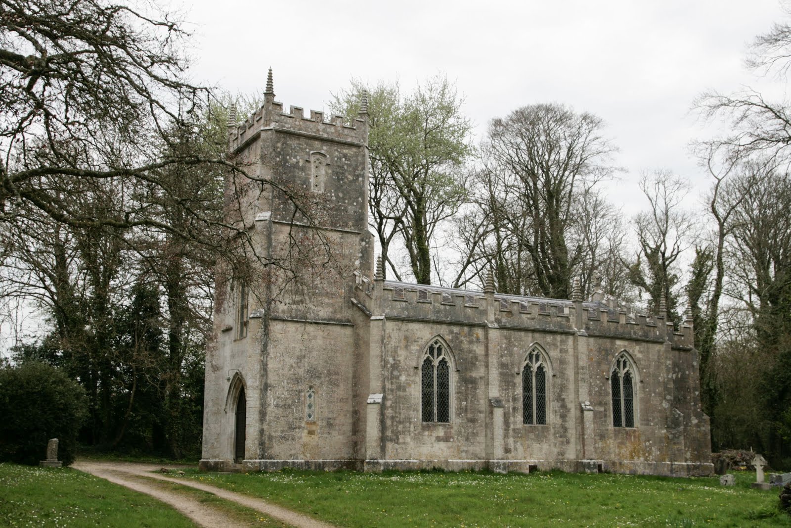
We parked at Houns Tout car park and walked back to the village of Kingston, where we popped into the church briefly, disturbing the organist at his weekly practice. For a small village, this is a huge church, gothic in style. Church building began in 1874 and was completed in 1880, so it is actually a relatively modern building, constructed from stone and marble quarried on worked on Encombe Estate, within whose grounds the church is situated.


St James' Church, Kingston - SY9579

Door handle on St James' Church, Kingston - SY9579
Stained glass window in St James' Church, Kingston - SY6579
We left the church and continued on the road southwards, past the private plantation of Encombe Estate. We were soon walking along a valley bottom, surrounded by newly born lambs and their anxious mothers, all baaing and bleating in turn.


Lambs at Westhill Farm - SY9578
It wasn't long before we could see a glimpse of Houns Tout Cliff.

Houns Tout from Westhill Farm- SY9578

We mused on whether or not we would like to live at the farm here, such an idyllic spot, but what about that road in winter!

Cottage on edge of Westhill Woods - SY9577

A bird with a reddish tail caught my eye. It was flitting amongst the bushes and I suspected it was a male Redstart. It stopped within close quarters and confirmed my suspicions. yes! What a gorgeous bird this is and what a treat to see! Our photograph is too poor to show, but that's because of the camera, not the photographer (naturally!)

We almost missed the turn off for the westwards south-west coast path as it was counter-intuitive to head inland rather than keep heading towards the coast. Thankfully, my fixation with maps prevented us from making a mistake and we were soon looking over Chapman's Pool from the west. Our previous visit had been to its eastern side.

Chapman's Pool - SY9577
We were now at the bottom of Houns Tout and could see the challenge which faced us - some very steep steps to the top of the cliff. We decided we needed refreshment before embarking upon our challenge. Also a group of very noisy women were laughing and screeching their way down the steps in single file and taking their time so we thought it best to let them get on with it rather than try and barge past them with vigour!

It was hard to fully appreciate the beauty and tranquility of this spot when there is so much background noise, but I was convinced I could hear a Grasshopper Warbler inbetween the mixture of
mirth and pain behind us. The lush vegetation west of Chapman's Pool must be largely undisturbed, being more or less inaccessible to humans, and remains therefore a paradise for wildlife. I was delighted to hear the Grasshopper Warbler and trained Paul to hear its reeling call, which he just managed to do before it fled.

The steps were now free and there was no escaping our task. The only consolation during this strenuous climb was a Violet Oil Beetle. We had seen one earlier in the month in Somerset, which had been my second ever and Paul's first,  so this was another treat of the day.

Violet Oil Beetle (Photo: Paul Dexter)

Having ascended Houns Tout, we now descended into woodland within which Encombe House sits. The woodland was glorious, the fresh smell of wild garlic wafting through the air.

Steps in Encombe Estate - SY9477

Wild garlic in woods at Encombe - SY9477

The name 'Eldon Seat' intrigued me, but the footpath did not pass by this feature, so it was only later that I learned of its meaning. It is a stone seat, erected in 1835 by Lord Eldon. There is a nearby grave for Pincher, Lord Eldon's favourite dog, a German Spaniel.

The stone seat has the following inscription on its east, north and west faces respectively :
“ELDON SEAT.”
” 1835.”
“THE FIRST STONE OF THIS SEAT WAS LAID BY THE LADY E. REPTON, THE ELDER DAUGHTER OF THE FIRST EARL OF ELDON, XV. OCTOBER, MDCCCXXXV.**

Our view from this gridsquare remained a coastal one.

Looking towards Rope Lake Head - SY9377
We paused to identify some Brown Tail larvae munching their way through hawthorn or blackthorn.
Browntail larvae

We crossed a wooden footbridge near Rope Lake Head, the point at which I was no longer in new territory and could relax as far as worrying about photographs for each gridsquare was concerned.

Footbridge near Rope Lake Head - SY9377
There was still plenty to see and hear though as flocks of Linnets skittishly alighted on parched ground and barbed wire fences, only to take off again a few seconds later spooked by something or other. Skylarks too were filling the air with their joyous song. Only the dearth of seabirds stirred a pang of longing for Islay. Can anything compare with that wild Atlantic coast with its cacophony of waves, Chough, gulls and wind?


Linnets near Clavell's Tower
Clavell's Hard - SY9277
Kimmeridge Ledges - SY9177
Look out tower at Cuddle - SY9178
Clavell Tower - SY9178
A new construction is being built at Kimmeridge of quite mammoth proportions. I managed to get a photo of them ore natural rape seed fields and coastline beyond as we passed by this honeypot.

Rapeseed, Kimmeridge Bay and Portland - SY9179
Kimmeridge is an attractive village with the disadvantage of never being left alone during the summer months. I would hate that. Its tranquil facade belies its seasonal marauded state.

Kimmeridge - SY9179
A garden with some natural driftwood sculptures caught my eye - now that's more my sort of thing!

Garden in Kimmeridge - SY9179
Rather than follow the road's torturous V-shape to our footpath eastwards, we headed uphill by the church, and what an uphill it was!

Steep steps north of Kimmeridge - SY9180
Thankfully it was short lived and we were soon on the ridge by a car park and looking for our footpath near the quarry. This was not to be found - another one that had been diverted since my 2004 version of the Explorer map. After a few false starts, we were eventually back on the footpath at the rather dis-concertedly named 'Hell Bottom'.

Hell Bottom - SY9180
Now we were ascending Smedmore Hill which afforded splendid views in all directions.

Smedmore Hill, looking west - SY9279

Smedmore Hill, looking east - SY9279

Smedmore Hill, looking north - SY9279
There were quite a few other walkers and cyclists around today and a group of people with a 4 x 4 who had parked their vehicle by the footpath and climbed over the wall for their picnic - right at the spot we wanted. Trying not to feel resentful, we pressed on into the next square, where we diverted from the main path, enticed by bluebells and a footpath sign to Smedmore House. We sat here with our picnic listening to the call of the Whitethroat and learning about the history of Smedmore House. One of Dorset's finest Georgian manor houses, it is available to hire for functions. It was originally built by Sir William Clavell around 1620, partially rebuilt by Edward Clavell around 1700 and extended greatlt by George Clavell around 1760. A dotted line is shown on the Explorer map, but we didn't know whether that was a permissive path or not, or whether it would join up with the south-west coast path, thereby providing a much shorter alternative walk.
Footpath in SY9379
Spring colours and Clavell Tower - SY9378
Not in any hurry, we lingered over lunch before setting off again through the delightfully named Heaven's Gate, a welcome contrast to the Hell Bottom we had just visited.

Heaven's Gate - SY9378
In my excitement about the name and view, I unclipped my camera hurriedly and unwittingly dropped my sunhat at this juncture.

We pressed on to Swyre Head viewpoint and trigpoint, where we were not alone in admiring the view on this glorious day.

Swyre Head trigopint - SY9378

View west from Swyre Head towards Clavell Tower - SY9378

East from Swyre Head - SY9378


Stile and westwards view from Swyre Head - SY9378
It was now that I realised my cap had gone and in the burning afternoon sun, I wanted to retrieve it. We started to retrace our steps and asked a couple approaching us if they had seen a hat. They had at the previous gate they informed us. Paul waited whilst I ran back to find my hat atop Heaven's Gate. I'm so glad it wasn't on Hell Bottom!

The footpath now takes a sharp turn from south-eastwards to north-eastwards where it follows the ridge overlooking Encombe House and runs past Polar Wood.


East from Swyre Head; Encombe Housr centre left - SY9378

Ridge northwards at Swyre Head; Polar Wood on left - SY9378
 The bluebells in Polar Wood were amazing, together with splashes of pink from the Red Campion and contrasting white and pungent scent of Ramsons, it made a breathtaking display.

Bluebells in Polar Wood - SY9478

Bluebells and Ramsons in Polar Wood - SY9478

Red Campion and Bluebells in Polar Wood - SY9478
A stone bench here commemorates those who lost their lives in aircraft disasters during the two world wars, whilst another plainer bench overlooks Encombe House.

Commemorative bench at Polar Wood - SY9478

Inscription on commemorative bench at Polar Wood - SY9478
Bench at Polar Wood - SY9478
We were soon at Swyre Head car park, from where it was a rather monotonous walk on the road past fields of crops to our car, but I had found my first entry into Dorset's gridsquare charts. With approximately 7,500 gridsquares I'm allowed less than one per 1000 gridsquares, but  SY9378 has definitely made it into the top ten with its variety of habitat, breathtaking views and floral displays.


Number of new gridsquares: 9
Number of trigpoints: 1
Number of times I lost my hat: 1
Number of miles: 9.8

Saturday, 23 April 2016

Upwey Circular

I started today's walk from Upwey train station. This means that I have either boarded or alighted a train from every station between Yeovil Pen Mill and Weymouth except Thornford - so that's a clue as to the starting point for my next walk. I started later than I like to - at 11 am, and had a time restriction for the walk, which I really don't like, but it was a lot quicker getting here than it would have been by car and it avoided the parking problem.

Upwey train station - SY6783

I headed west and immediately into another gridsquare through which the busy A354 runs, the main road between Dorchester and Weymouth. Although this is called Upwey station, I think it is more correctly Broadwey. I had the feeling of being in urbanity for a long time after I started this walk; usually I feel like I'm in the country straight away.

Anyway, I set off across fields towards Nottington and crossed the diminutive River Wey.

River Wey at Broadwey - SY6683

When I hit the  minor road north of Nottington I almost did a right angle and headed north towards a minor ridgeway and walked parallel to the Jubilee Trail and the ridgeway walk we'd done months ago at Friar Waddon. That walk had afforded great views, partly because the weather was better, but also because it is higher up. During my quick perusal of the map before I set off I had not appreciated I'd be much lower down - just that I'd manage to do a lot of gridsquares and visit a few churches - always a good thingin my books. So we can't have everything!

I was walking almost two complete 'sides' of SY6583 so was in the square for a long time. I still managed to miss the trigpoint, which had been another attraction on this walk. Apparently Broadwey trigpoint is in the middle of a hedge and not at all easy to find. Another one to return to in the winter months when the vegetation is less dense.

I was intrigued by Jones's/Jonas's Hole as I have not come across many ruins during my walks, let alone named ones (unlike Islay where there is a plethora of ruined buildings to make the subject of an atmospheric monochrome photograph). I approached the ruin with caution. It was submerged beneath a jungle of ivy and was barely visible. The place felt eerie so I did not linger. Had I had a companion I may well have explored a bit more.

SY6583 - Jonas's Hole

The next field was full of rapeseed and skylarks - a wonderful assault on the senses and I love signposts that are so specific. There was one pointing to Jonas's Hole (even though I've subsequently been unable to find out who Jonas was).

Sign on Hewish Hill - SY6483
Hewish Hill looking towards North Farm
Sadly a troop of unsightly pylons scar the landscape here; whichever way you look, there they are. And they are so BIG! I'm always a little frightened when I walk beneath pylons and hear their electrical chatter. Are they going to zap me? Walking so close to all that power seems to me to be quite a risk, especially in high winds or a thunder and lightning storm. Not that it was anything but the most innocuous of weathers today as I walked under three sets of buzzing wires during my brief sojourn in SY6484.

Looking north towards the ridgeway - SY6484

I was skirting the southerly edge of the next gridsquare, SY6384 and soon came across my second ruin of the day - Corton Dairy House. This one was also difficult to access with a bushy growth of nettles and unwelcoming brambles. Again, I have been unable to discover anything about the history of this place, although it obviously used to be the dairy for the hamlet of Corton which is largely situated a little further north near Friar Waddon.

Corton Dairy House - SY6384

Another right angle turn and I followed the length of the next gridsquare southwards to Tatton House along a veritable farm track.

South  from Corton - SY6383
I then followed a minor road until I reached Hyde Coppice and a footpath leading southwest past Broad Coppice. A glance into the private woodland elicited an audible gasp of wonder and delight, for there was the most stunning vista of bluebells I have ever seen. I had had an assault of yellow today and now it was heavenly blue. Everywhere I looked - blue. I imagined a heady scent (for it wasn't really there) as I breathed deeply in and wished for the millionth time in my life that a photo could do justice to a scene. I also wished it were possible to walk in the wood, but it is clearly marked dangerous due to archery practice.

Bluebells at Broad Coppice - SY6382

Bluebells at Broad Coppice - SY6382
After a huge helping of bluebells, I continued my walk, passing a massive solar farm, heading south across unremarkable farmland. towards another ruin. I'd been walking a little uphill so this barn was appropriately named Higher Barn and was quite a substantial ruin.

Solar Farm near Buckland Ripers - SY6482
Higher Barn - SY6482
The next gridsquare contained a lot of newly planted trees.

Fields and newly planted trees near Chickerell - SY6481
I crossed the southwest corner of SY6381 near Manor Farm before reaching and crossing the B3157.
Near Manor Farm - SY6381

As I headed towards Fleet, my hunger pangs grew stronger with each step. I just hadn't seen anywhere suitable to stop and eat lunch. Besides, I like to have lunch in a churchyard. I'm stopping anyway to have a look round, so I might as well stop and eat at the same time - that's my theory. The other reason for delaying lunch was that I was a little anxious about getting to the train station on time. I'm not used to walking with time restrictions and try to avoid it whenever possible. I get jittery if I'm walking with someone who (quite reasonably) asks how long the walk will take. When i go out for a day walk I don't think about what time I'll get home. I've got enough food and water for the walk and nothing to get back for and that's all that matters to me. I do recognise, however, that this is a privilege that not everyone has, so I try to be tolerant when asked that (very reasonable!) question.

Time restrictions or not, I considered 7 miles long enough for anyone to walk before having their first stop so I plonked on the steps at Fleet New Church.

Church of Holy Trinity, Fleet - SY6380

Thew new church at Fleet was built to replace the old church which was virtually obliterated by the Great Gale of 24th November 1824. The first church had been built very close to the coast and so was washed away by huge waves during the storm. The present church was commissioned by the Rector, Rev George Gould and  built further inland a few years later.

There were two cars parked in the churchyard, so I assumed maybe there was a cleaner inside, or perhaps someone practising the organ for Sunday. But I was alone in my wanderings until a pair of walkers returned to their car. I later discovered this is in fact a public car park - a point worth remembering in the future.

Inside Fleet Church
Memorial to the lord of the manor, John Gould who died in 1818.As a tribute of the deepest sorrow and sincerest affection - This monument is erected to the memory of John Gould Esq of Upway and of Fleet House in this parish. Eldest son of the late George Gould Esq and of Abigail his wife, youngest daughter of the late Robert Gooden Esq of Overcompton in this county who, to the heartfelt grief of all those who love him most by knowing him best, was prematurely taken away by an acute and rapid disease on the 26th day of August in the year of our Lord 1818, in the forty-third year of his age. Deeply imbued with principles of ancient worth and honour he was a worshipper of truth - A friend to the poor - scrupulously conscientious and most punctual in the private as well as public exercise of his religious duties. Exemplary in his domestic relations, of a superior and highly cultivated mind, he was well qualified to act in those more ostensible stations to which he preferred the doing good in private life.He remains at rest with his ancestors at Upway, but since it was in this parish that he set so praiseworthy an example of regular attendance on Sabbath service his ever lamented name is by his only brother here recorded. Stranger whoe'er thou art whose steps have strayed to this lone hamlets unfrequented shade If genuine worth they kindred soul can move, to feel for those who mourn the friend they love, Oh! think what pangs their swelling hearts sustain, who dwell on lifes best virtues lost, in vain, In healths high glow and manhoods summer pride, The best of brothers, sons, and masters died, Oh! Hadst thou seen that melancholy day, When the long funeral filled the silent way, From humble breasts how heaved the sigh sincere, From cottage doors how trickled many a tear, Thou woulds have said, ye pennons high that wave, or o'er the hero's or the statesman's grave, Oh! What are you in all your pomp of fame, To these sweet honours of the good mans name!


Feeling refreshed, I continued my walk along Fleet Common towards Fleet Old Church, passing the delighfully named Butter Street on the way. The chancel is all that now remains of the old church, all that visibly remains that is. There is a distinct presence of memory here in the poignancy that lashings of tidal waves could destroy part of a church whilst remarkably leaving a small portion untouched.

Fleet Old Church - SY6380
Inside Fleet Old Church
The church is no longer used regularly for worship, but contains several memorials to the Mohun family who feature in J Meade Faulkner's famous novel, Moonfleet, which is based on real life events, such as the fact that smugglers' contraband was hidden in the church vaults alongside the coffins!

My route to Fleet later looked like The Oa peninsula on Islay - that's exactly what I thought when I looked at it, but I had lingered long enough in this gridsquare and was conscious of the time. I left the village behind when I exited the 'handed' gates. Apart from these intriguing little flags  I saw quite a few St George's Flag flying high. There were quite a few flags flying today to celebrate the Queen's 90th birthday.

Entrance to Fleet - SY6480
I crossed the B3157 again and entered Chickerell. The sky was growing darker and a few spots of rain fell, making me wonder whether I should secrete my camera and binoculars away. There was no need, however, as the rain didn't last long and had stopped by the time I came to St Mary's Church in Chickerell, which i rather liked with its colourful kneeling cushions and very old pulpit. Despite a thorough search, I could not find the scratch mark on its southern face. There are lots of scratch marks on Somerset churches, but they are rarer on churches in Dorset so it would have been nice to see it. Scratch dials were used by clergymen to tell the time in the days before clocks. A hole was inserted into the south wall of the church and marks made around the hole. A stick was inserted into the hole and its shadow told the time. But what happened if it wasn't sunny enough to cast a shadow, I have always wondered?

St Mary's Church, Chickerell - SY6480
Date on the beautifully carved pulpit


From the gallery

Apparently the smallest of the church's two bells dates from around 1300 and is Dorset's second oldest church bell (I don't know where the oldest is)

I walked across the south-west corner of SY6481, a square I'd previously walked in on my approach to Chickerell and therefore did not need to find anything else to photograph; I was tiring now. There was nothing to write home about at Coldharbour either so I snapped a quick photo of the road as I trundled wearily along.

Coldharbour - SY6581

At Harbourbridge (which sounds lovely, but isn't), I struck another right angle and walked northwest into SY6582. I nearly didn't do this section as I thought time was too short and I could easily have just walked along the road back to Upwey and saved time. but the historical church at Buckland Ripers clinched it. It needn't have really as the church was maddeningly locked with no information as to where to obtain the key. Still, it is a delightful little building and definitely worth returning to with information about looking around.

St Nicholas Church, Buckland Ripers - SY6582
The walk north-west was not a total waste of time, however, as I crossed a beautiful stone stile with an inscription to Flt Srgt Frederic George Ward, a local farmer's son and pilot who, at the tender age of 20 was killed when his Mosquito plane crashed in Suffolk during the Second World War. There is an Ordnance Survey rivet benchmark on the stile, which made it even more interesting.

Stone stile and memorial to Flt Sgt Frederic George Ward - SY6582
Rivet on the stone stile near Buckland Ripers

My detour to the church meant retracing my steps (through three gates and smelly cow doings) and choosing a path - north or south of the River Wey? I chose south as there was supposed to be another benchmark along here somewhere, but most of the ones listed as being on gateposts are now long gone, the stone gateposts having been replaced by treated wooden ones.

My approach to Nottington was memorable because of two yappy dogs which frightened me and almost made me reconsider the northerly path. Their owner made a feeble attempt at calling them to heel, but she was too engrossed in her horses to make much of an effort so I braved their vicious jaws and plodded on. The village is quite attractive and the River Wey runs through it.
Nottington Village - SY6682
River Wey at Nottington - SY6682

Octagonal Spa House at Nottington - SY6682, built around 1830  by Robert Vining
for its patrons to partake of the sulphuric waters that were said to be so beneficial to the health.


Having been assaulted by yellow and blue flora, it was now the turn of the white Blackthorn to take my breath away. It has such an ugly name and can deal a sore blow with its prickles, but it really is so pretty in flower.

Blackthorn at Nottington - SY6682


I was now back at Broadwey and came quite suddenly back to the station with twenty minutes to spare before my train. I spent much of that time munching a last sandwich and talking to a friendly teenager who kept me company throughout the forty minute journey home.

Distance: 12.3 miles
Trigpoints: 0
Benchmarks: 8
Churches:  3 1/2
Gridsquares: 17