Friday, 6 January 2017

Puncknowle Circular - 29th December 2016

I have done several walks since my last post, but a combination of no WIFI and Christmas/New Year has meant a distinct lack of opportunity to blog about them, so I shall have to content myself with writing about my latest two walks, otherwise I'll never get anything done.

In any event, I have done a count almost to date and I've managed to walk in about 600 of Dorset's approximately 7000 1 km gridsquares. Considering it took me ten years to do Islay's 742, I'm quite pleased with that total!

After a mild, wet, and windy few days on Skye, we stepped off the plane to glorious sunshine last week and the wonderful cold, crispy air which has come to compensate for the lack of wild Atlantic coastline and ruggedness of my adored erstwhile island home. I hoped it would be as pleasant the next day and promised myself a solitary gridsquare walk if it  were.

It were, or rather was, and I chose Puncknowle as my starting point and now I'm not quite sure why. The roads were icy and I drove with care to the village, donned my walking boots and set off in the wrong direction. This was how much I had come to rely on my Memory Map phone - and I had neither with me today. The phone I had left on wild and windy Skye and, consequently I couldn't have memory map loaded onto it. I prided myself on my map reading ability and told Paul I was glad of the opportunity to go digital mapless and rely on the good old-fashioned paper map.

In fact it was fun. I navigated with care and got myself back on track and through the village of Puncknowle, past The empty Crown Inn and headed westwards along Looke Lane. I love it when roads have got local names like that and would love to know all their origins.

The Crown Inn, Puncknowle - SY5388

I walked along the minor road, having to step onto the grassy verge two or three times, before turning off onto the footpath for Looke Farm Dairy House. There was a pistol range here which thanked me for supporting 'Shield No Limits', even though I wasn't sure that I had. I preferred the attractive letter box set within a wall.

Pistol Range sign at Looke Farm - SY5488
Letter box at Looke Farm - SY5488

This is the land of the dairy houses - my next landmark was Park's Dairy House. There was nothing significant here other than lots of squelchy mud and the feeling that these footpaths had not been used for a very long time. It was a beautiful day and I was squelching through mud and getting lost. At least I realised it before I'd gone too far and at least I resisted the temptation to find a shortcut once I realised I was lost. I've learned from past experience that the best thing to do when you realise you've gone wrong is to turn round, retrace your steps and get back onto the right footpath - however much it might look like you can just cut across this field or through that gate.

So I went back to Park's Dairy House and found the track to Chapel Coppice.

Chapel Coppice - SY5588
This was my third visit to Chapel Coppice and my intention had been to visit the Chapel in the Woods and complete a poem I had started there on my last visit. The Chapel was built in Ashley Chase in the 16th Century, the land having been granted to monks in the 13th century  in exchange for perpetual prayers being said. The chapel is now ruined and derelict, but originally measured  32 x 18 feet and was dedicated to St Luke. St Luke's and the monastery sadly quickly fell into dissolution and all that remains now is the west wall, an altar with a crucifix and two tombs of  David and Olga Milne-Watson who built Ashley Chase House.


Angel in St Luke's Chapel - SY5587

St Luke's Chapel and crucifix with the tombs in the centre of the photo - SY5587
The usual plethora of incongruous tat adorned the altar and crevices of this once sacred place. I preferred the ivy and moss. The muse did not appear, however and instead I felt a little spooked - I don't know why, so I had a quick coffee stop and left the chapel and its inhabitants in peace with my poem still half-written.

I retraced my steps through the wood back to the track which led to the coast via Abbotsbury Castle, noting a great example of inosculation on route (where two trees are fused together)

Inosculation in Chapel Coppice - SY5587


Abbotsbury Castle trigpoint - SY5586
The trigpoint sits on top of an ancient fort which is more distinctive when viewed from the west. It really does look like a fort from that angle, and one with a rather splendid view too.

Abbotsbury Castle from the west - SY5586
I was keen to see whether Labour in Vain Farm had a sign from the eastern side (just because it's such a nice name) but there was no public access. I walked quickly to the coast, having already photographed that gridsquare - SY5486.

At Chesil Beach I was keen to get photographing once more, my camera having been rather redundant of my stomp through previously visited gridsquares.

Chesil Beach from Burton Road - SY5485
I was also keen to have lunch so chose a conveniently sited bench to eat and watch the fishermen before setting off through several gridsquares. some of this was a hard slog as walking through those tiny stones is gruelling work.


Chesil Beach - SY5386

 I'd got some of these gridsquares already, but the weather was so nice, I couldn't resist clicking away anyway. My next 'serious' gridsquare was SY5286 where two footpaths headed inland through West Bexington Nature Reserve. I passed a few dog walkers, all lifting heavy feet through tiny stones. My footpath lie further still along the south-west coast path.

West Bexington Nature Reserve - SY5286

West Bexington Nature Reserve - SY5286
At SY5287, I turned inland towards Swyre, crossing another small footbridge across the stream.

Footpath to Swyre, SY5287

I vaguely recalled this footpath as we had walked here last February with my daughter. It had been very muddy then and was not as bad this time. I walked past a sprawling caravan site and into the village of Swyre where I made a point of visiting the church and learnt from an excellent hand-drawn Millenium Map that Grey Long-eared bats used to roost here. "Mmm, Paul would be interested to know that," I mused, snapping a photo to remind me.

Millenium Map at Holy Trinity Church, Swyre - SY5288

Holy Trinity Church, Swyre, SY5288

There is a pub called The Bull Inn here with a huge red bull statue outside and the lane I was to walk along back to Puncknowle was called Bull Lane. "Maybe someone got attacked by a bull here," I ruminated as I cautiously walked along said lane.

The Bull Inn, Swyre - SY5288
Back at Puncknowle, I admired the Christmas decorations in the church before setting off for my final gridsquare of the day.

Nativity Scene at St Mary's Church, Puncknowle - SY5388

On the aforementioned walk with my daughter in February, we had noticed a small ruined building set atop Puncknowle Knoll and wondered about its purpose.  Puncknowle Knoll used to be known as Punnell Knob or Nose (Puncknowle is pronounced 'punnell'). No-one seems to know the true origins of this tiny ruined building with a panoramic view. Several explanations have been postulated - gazebo for a local landowner, a look-out during smuggling days or during the Napoleonic War. Whatever its purpose, it is worth the short walk from the road up the hill to peep inside and ponder who lived here, who looked through these windows, lit a fire? What has changed in the surrounding countryside and what remains unchanged? Eternal questions for eternal stone and a lovely place to end my day.


Puncknowle Knoll lookout - SY5387

Number of times got lost: 3
Number of red bulls: 1
Number of new gridsquares: 4 (only 4??  Good job I'm not just doing it for the gridsquares!)
Number of trigpoints: 1
Number of ruined buildings: 1
Number of churches: 3
Number of miles: 9.5


Thursday, 8 December 2016

Worth Matravers and Dancing Ledge

It was a dull day, but a good opportunity to get some new gridsquares with some friends. We hope to return on a sunny day in spring to see the rare Spider Orchids here and take better photos, but for now I was happy to bag quite a few squares.

St Nicholas of Myra Church, Worth Matravers - SY9777

Grave of Benjamin Jesty (left) who discovered the small pox vaccine and was born in Yetminster. His wife's grave is next to his. - Worth Matravers graveyard - SY9777
We headed north before turning southwards towards the coast. A few attractive cottages nestle at Hill Bottom.
Hill Bottom - SY9677
We followed a beautifully crafted dry stone wall on our route coastwards, which was further enhanced by the inclusion of some large stones on which were engraved some inspirational quotes.


Held by Gravity - SY9577
I had heard the name 'Chapman's Pool' many times and seen it signposted from Kimmeridge, so was delighted to suddenly happen upon it, albeit from some height. A further exploration was called for at a later date.

Chapman's Pool - SY9577
We passed more quotes and outstanding views of the coastline.

SY9576

SY9576
View westwards from Emmett's Hill - SY9576
The views were outstanding until we reached the most gruelling set of steps i think i've ever come across - all 10,00 of them - or maybe closer to 200 - I think they've been counted!

Ascending St Aldhelm's Head from SY9576
We were glad to reach to top and admire the view.

View from St Aldhelm's Head - SY9575
Bench at St Aldhelm's Head - SY9575
Then we visited St Aldhelm's Chapel, which is a little gem. 

Inside St Aldhelm's Chapel - SY9675

St Aldhelm's Chapel - SY9675

St Aldhelm's Chapel - SY9675
We were missing a trigpoint which I'd have to come back for on another occasion. We continued on the south-west coast path, passing some outstanding scenery en route to Winspit Quarry.

Stack near West Man, South-west Coast Path - SY9775
Hoping to hear bats in Winspit caves, we were sadly disappointed. We'd come to the wrong place, impressive though these quarries are. 

Winspit Caves at Winspit Quarry - SY9776

Winspit Caves at Winspit Quarry - SY9776

Inside Winspit Caves at Winspit Quarry - SY9776
A large ammonite fossil was a reminder of the fossil-rich coastline we were walking along.

Ammonite - SY9776
Distractions or tiredness made me miss the next gridsquare so my next new gridsquare was going to be our lunch spot at Dancing Ledge, a place named after the dancing action of the waves caused by the wind on stormy days. I'd love to return and watch that dance!

Dancer's Ledge - SY9976
The only other remarkable thing about the next gridsquare was that we had passed unwittingly into 'SZ' territory (I have a feeling I was the only one to notice!)

Near Blacker's Hole - and 'SZ' territory - SZ0076
The next gridsquare was also our turning point northwards and was marked by big mile markers. Apparently these two sets of two tall pylon-like structures mark a nautical mile. When viewed from the sea,  the mile starts when the two posts are exactly lined up one behind the other when viewed from the sea and finishes when same happens at the other end.

Mile marker - SZ0176
Once more tiredness got the better of me and I missed two gridsquares (although it is difficult to surreptitiously check the map, walk and talk to walking companions all at the same time so it might not just have been tiredness - in my defence!)

At any rate, the next time i was able to check I was in SZ0078 but felt very disorientated as, according to the sign, we were walking back to Dancing Ledge. How was that possible? We were surely heading in the other direction? I've just about worked it out - I think!

Sign which threw me - SZ0078
A lime kiln also called for further exploration another day.
Lime Kiln near Worth Matravers - SZ0078

Eastington Farm provided a photo feature for the next gridsquare without much effort being involved - my legs now feeling like jelly.

Eastington Farm - SY9877
Tired and ready to drop though I was, I couldn't resist a final photo for the day when I saw this diagonal dry stone wall near Worth Matravers. Thanks to Steve for leading such an interesting walk.

Attractive dry stone wall near Worth Matravers - SY9877
Number of new gridsquares - 13
Number of missed gridsquares - 6
Number of miles walked - 11.2
Number of stone steps - approx 200

Short walk at Abbotsbury

Of course, it's all relative. A short walk to us is anything shorter than 10 miles; to some people, a short walk may be anything between 100 yards and 2 miles, whilst we know some people who would perhaps consider anything under 20 miles a short walk. At any rate, in this case, our 'short' walk was 7.5 miles on a beautiful late November day.

I had decided I'd like to explore Abbotsbury. Really, I'd wanted to go the day before on St Catherine's Day but, having discovered that the special service for St Catherine's Day had been held the Sunday before, and not on the actual St Catherine's Day, we decided to go on the day with the better forecast instead.

We'd been several times before, but the only time we'd been up St Catherine's Hill we hadn't ventured inside the chapel. So this was to be our first time. At first I was disappointed, deciding that this barrel-vaulted 14th century chapel was much better viewed externally where it draws the eye from miles around.

St Catherine's Chapel - SY5784
There is not much to see in the interior, but it was here that maidens came to beseech St Catherine, their patron saint, for a husband. Legend has it that there are two hand holds in the south entrance to the chapel with a ledge for the knee where maidens repeated a prayer along the lines of:

'A husband, St Catherine. A handsome one, St Catherine. A rich one, St Catherine, A nice one, St Catherine, And soon, St Catherine.'

P J Harvey, who lives locally, wrote a song about St Catherine, 'The Wind' and apparently came to sing in the chapel. I did discover that the acoustics were good here and wrote my own poem about the patron saint and this particular legend and recorded it on my phone on my next visit.

Having contemplated the patron saint, we left the chapel and admired the strip lynchets on the hill to the west, which was the direction we were now going to walk in the hope of 'filling in a gap' left from previous walks on this stretch of coastline.

Strip lynchets - SY5684
There wasn't much opportunity to get a photo in the next two gridsquares, but some unusual cottages provided a chance.

Cottages on the south-west coast path near Abbotsbury  - SY5584
Lawrence's Cottage with cirrus clouds - SY5585
We ventured onto Chesil beach for the next square - and our lunch, choosing the relative shelter of an old World War 2 pill box to eat our picnic.


Pill box on Chesil Beach - SY5485
The old coastguard cottages here have some amusing names. I wonder whether there's a story here.

Matthew, Mark, Luke and John - SY5485
We didn't really need to go into the next gridsquare before turning north as we had forgotten about the permissive path which leads up to the most beautifully named farm I think I've come across, 'Labour in Vain'. However, needs must! If I didn't walk those few gratuitous steps now, when would I be motivated to do so again?

Coast path near West Bexington - SY5385
We turned northwards now, past a World War 2 gun emplacement and up Long Gully, which is appropriately named!

World War 2 gun emplacement near West Bexington on Long Gully - SY5485
I was disappointed not to see a sign for Labour-in-Vain Farm; perhaps there is one on the other side.

Labour-in-Vain Farm - SY5486
The long, hard slog now became even steeper as we ascended Turk's Hill to the B3157. From here, the distinct profile of Abbostbury Castle, an ancient fort, can be appreciated. 'This would be my choice of fort if I'd lived in those days,' I told Paul

Abbotsbury Castle - SY5586
Although we had walked this part of the south-west coast path before, it had been an incredibly windy day with a large group, so we didn't have a good, unobstructed view of Abbotsbury Castle trigpoint. All on our own today, and with clear views, we got a better photo.

Abbotsbury Castle trigpoint - SY5586

We passed another military relic - this time in the form of an ROC post, or nuclear bunker as I kept calling it. Once open to the public, it has now been well and truly closed off so you can't go down and see the bunk beds and 'stuff''.

ROC post at Abbotsbury Castle - SY5686

Then some ancient history - some tumuli, a reminder that the ridgeway has been used throughout the centuries as a place of defence and burial.

Tumulus, Abbotsbury Castle - SY5686
We were nearly back to our starting point now and had wonderful views of the Fleet and St Catherine's Chapel with a small loch in the foreground.

St Catherine's Chapel and The Fleet with small loch - SY5786
This marked our southwards turning point back to Abbotsbury.

Abbotsbury from the south-west coast path - SY5785
We visited St Nicholas' Church and learned of the marks of the Civil War which are left there in the bullet holes in the pulpit.

Bullet holes from the Civil War on the pulpit in St Nicholas' Church, Abbotsbury - SY5785
St Nicholas' Church, Abbotsbury - SY5785
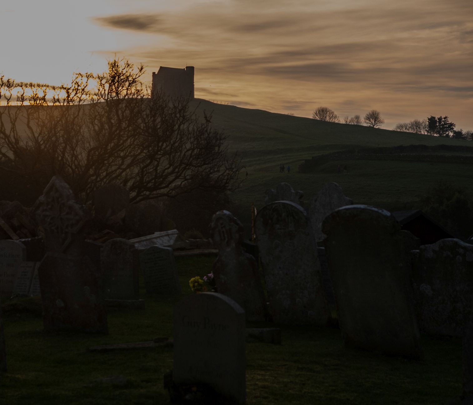
Watching the descent of the sun over such an inspirational landmark was a fitting end to our day's walk and contemplation.

St Catherine's Hill and Chapel at sunset, from St Nicholas' Church, Abbotsbury - SY5785
Number of new gridsquares - 11
Number of trigpoints - 1
Number of bullet holes - 2
Number of war reminders - 4
Number of miles walked - 7.5
Number of pieces of cake consumed at end of walk - 2
Number of churches - 2