Friday, 6 January 2017

Tyneham to Kimmeridge - 2nd January 2017

I've decided to add the date to my posts as I've got a little muddled with the dates and my latest posts have not been posted in chronological order and I'm not tech savvy enough to know how to move them around - nor have I the patience to learn! (Paul please don't admonish me!)

For our very first walk of 2017 (other than from the front door to the car door), we chose to go to the coast and fill in a bit of the south-west coast path that we haven't yet done. We've managed to do quite a bit of the Dorset coastline in different stages, and I'm actually beginning to feel that sinking feeling I get when nearly completing a book I've loved. I find I don't want to finish it; it has become a friend. Likewise the Dorset coastline. Oh well, that was the aim of this game, so off we set with fresh eyes from Tyneham where we joined the throngs of other bank holiday makers who obviously had the same idea as us - get out while the sun is shining - New year's Day, like Christmas Day, having been a complete wash out.

My first new gridsquare was one with a curly red arrow and Worbarrow Tout. We took two steps forward and slid one step back up the hill, past the big red number 3 and did not get much further. I really wanted to get to the top but, at our age, it seemed quite treacherous - not that we're wimps or anything!

What a glorious, amazing view from here!

From Worbarrow Tout - SY8679

Worbarrow Tout - SY8679 (if you look closely you'll see some braver souls than us approaching the summit!)
We turned eastwards now and ascended Gold Down. I wished I'd planned this better and started from Kimmeridge as the view walking westwards is much nicer. I kept turning round to look at Worbarrow Bay, where we seemed to have left most of the other Bank Holiday makers (fortunately).

Ascending Gold Down - SY8779

Worbarrow Bay - SY8679
The signs warning everyone that cliffs are dangerous are a tad overdone. Everywhere you looked there was a sign of some sort - either to warn you that this was a military zone and that you might tread on unexploded ammunition if you stepped outside of the yellow markers or that if you went too close to the edge you might fall off the cliff! I wondered how many people who didn't already know that came to these parts.

Danger Sign - SY8779


Gad Cliff is best viewed from the east, ie, in our case, once we'd walked past it.  Totally inaccessible by foot, we pondered on how much wildlife must thrive in this undisturbed territory.


Gad Cliff - SY8779

We passed a turn off back to Tyneham Farm and continued eastwards in a biting north-easterly wind.

Signpost to Tyneham Farm - SY8879
We found some shelter at Tyneham Cap and sat on a bench with our picnic, which it turned out was not very nice. The pitta bread which we'd defrosted that morning must have been in the freezer for months and was rather stale. Never mind, we munched away at the rest of our lunch and packed our bags to set off again.

Towards Kimmeridge - SY8879
Tyneham Cap - SY8979
Broad Bench stuck out like a photographer's out of bounds paradise. I longed to get down there and take close ups of the well, broad bench or shelf of rock but couldn't for two reasons: 1) it's dangerous (I worked that out for myself despite there being no signs to tell me) 2) It's forbidden territory outwith the Ranges walks (there was a sign to tell me this). This gridsquare would have to be photographed from another one, with a rubbish photo taken just within the gridsquare to count (hopefully) as a geograph for that square (don't worry if you didn't follow all that - it's anorak stuff!)

Broad Bench - SY8978
Kimmeridge Bay was now in sight, a place we'd visited several times before and it proved to be at least as popular with visitors today as Tyneham.


Kimmeridge Bay - SY9079
I ventured a little closer to the edge to get close ups of the amazing rocks.

Rocks at Kimmeridge - SY9079
But something else had drawn our attention, something I don't recall having seen before and that Paul started to get very excited about - a nodding donkey. And it looked like we might be butted by it if we went any closer.

Closing the Ranges gate behind us (which we didn't climb due to it being 'naughty' and 'dangerous' apparently), we went to investigate.

Amusing sign on the gate at the Ranges - SY9079
The Nodding Donkey at Kimmeridge - SY9079
The Nodding Donkey is a pump, in this case it is the oldest continually working oil well pump in the UK, having been continually pumping since 1961 and yielding between 65 and 80 barrels of oil a day .(It used to produce about 350/day.) An unusual feature for my gridsquare photo and an unexpected sighting today.

We were now turning inland to the 'boring' part of the walk. The first part was not quite as interesting, being through very muddy, ploughed fields, past Kimmeridge Coppice where I thought for a second I'd seen a Crossbill, but which turned out to be Chaffinches.

Looking towards Kimmeridge Coppice - SY9179
Then there were some steep steps to climb - and we weren't even on Ridgeway Hill yet!

Steps near Kimmeridge - SY9180
We slipped our way down to Steeple Leaze Farm, our boots getting rather clogged up on the way.

Steeple Leaze Farm - SY9080
Joining the road at SY9081, I decided to take a photo of that gridsquare from the Ridgeway as it was difficult to relax with quite a few  cars rushing by and having to keep ducking into the sides of the road. Being fond of the Dorset signposts, I took a photo of the sign to Steeple, somewhere we'd visited last year.

Sign for Steeple - SY9181
It's quite a slog up to Ridgeway Hill, but the view is worth it when you arrive.

View east from Ridgeway Hill - SY9281

On a previous walk I'd walked east from here towards Corfe Castle; today we were walking westwards on this extension to our original walk. We passed a drunk boundary stone and it was difficult to see exactly what it was boundering these days.

Boundary Stone on Ridgeway Hill - SY9281
I was quite excited about passing the Grange Arch, a feature I'd wanted to see for a long time, although I can't now figure out why. If you look carefully on the right-hand (eastern) pillar of the central arch, you'll see a benchmark (not in the photo, silly - when you're there in real life!)

Grange Arch - SY9181
It's an easy walk along a track from here to the road and the sun was low in the sky. "It's at that annoying height," Paul moaned as we walked into its full glare. i took issue with this statement, claiming that anything that was doing what it was naturally intended to do could not be deemed 'annoying'. "Only things that can be helped can be annoying," I argued, "like someone picking their nose or driving too fast, things like singing out of tune or it getting dark cannot be annoying."

The sun lighting up the track on Ridgeway Hill - most definitely not annoying - SY9081
Soon we were at the car park and a huge puddle with another amusing sign prohibiting motorised vehicles outwith the shooting season. It seemed rather a redundant sign to me as there surely couldn't be much such traffic along the track to warrant a highway sign like that.

Gate and Puddle on Ridgeway Hill - note the rather unnecessary sign - SY9081
We walked through the car park and then along the road until we reached the footpath that runs parallel to the road. Here I took a photo of an unusual building.

Ruined building on West Creech Hill - SY8981
We walked along a leaf-strewn path lit by golden sunlight.

Leaf-strewn path on West Creech Hill - SY8981
Then we walked along the foot of Povington Hill.


Footpath at Povington Hill - SY8881
The late afternoon sun lit our path as we trod the last of our 10 miles back to the car.

Approaching Tyneham from the north - SY8780

Number of signs: innumerable
Number of new gridsquares:14
Number of miles: 10.3 
Number of donkeys: 1

East and West Lulworth - 4th December 2016

Since moving to the south-west I've acquired several books about the history and natural history of the area and, having an inquisitive mind and, initially at least, time on my hands, I set about learning all I could about the new places I'd yet to discover.

One such place was Lulworth Castle. We'd visited Lulworth Cove in the height of the summer last year and, having read so much about it, I have to confess I was disappointed. Any potential views were marred by a muddy field of uniformly grey cars, ice-cream stalls and throngs of people on every square inch of beach. Despite its legendary status as one of Dorset's beauty spots, Lulworth has quite an ugly beach; viewed from above it is attractive and admittedly sheltered as it is nearly entirely enclosed and protected from the elements on all but the most southerly side, which, along with its accessibility, make it an attractive spot for families. Of course these families have to pay the price for such facilities with expensive car parking. The beach itself is difficult to walk on and there is hardly any sand and seemingly nowhere to investigate rockpools, so it's not what I remember from my childhood days as being a typical family beach. Nevertheless, the surrounding area is beautiful and we decided to revisit on a winter's day and visit Lulworth Castle as well.

The attraction of Lulworth Castle was its Roman Catholic chapel. Apparently in the eighteenth century catholics could be persecuted for their faith so the Weld family, practising catholics, were advised they could  build a catholic chapel on their estate provided it did not resemble a religious building. Hence the building which stands there to this day under which, thankfully there is no longer any threat of persecution.

Our day began in glorious sunshine at St Andrew's Church at East Lulworth, where a wren had found its way into the building and seemed trapped. We kept the doors open whilst we were there and assume it got away; we certainly could not find it when we exited the church. 


St Andrew's Church, East Lulworth - SY8582

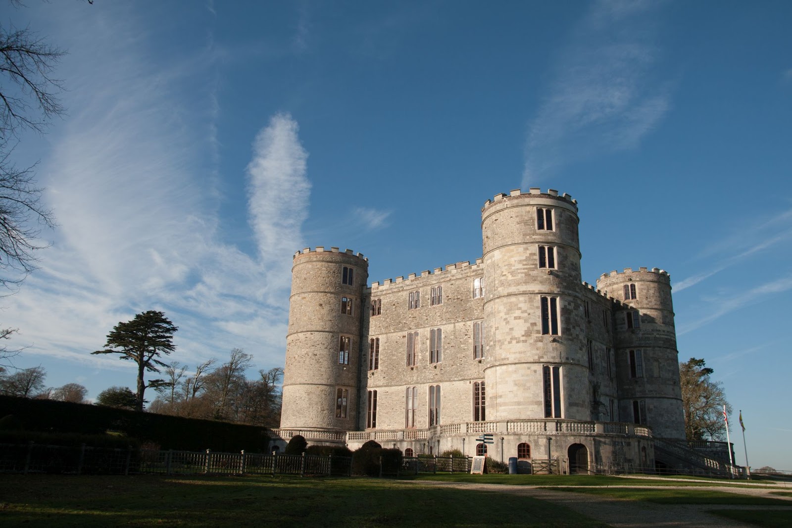
Our next stop was the Castle, just next door to the church. At first we were reluctant to spend any  daylight hours indoors on a day like today, but our reservations were soon swept away by the wonder of the Castle.

Lulworth Castle - SY8582

The Castle was completed  in 1609 and bought by Humphrey Weld in 1641.  Almost completely destroyed by a fire in 1929, the castle has been restored by English heritage and reopened in 1998. Still owned by the Weld family, it is now a major tourist attraction with mediaeval-themed events. The current Weld family reside in a separate building on the same estate. 

Christmas tree inside Lulworth Castle - SY8582

Suit of armour inside Lulworth Castle - SY8582

Door buckled by fire inside Lulworth Castle - SY8582

Inside Lulworth Castle - SY8582

King Charles' bedroom - inside Lulworth Castle - SY8582

St Mary's Roman Catholic church, East Lulworth - SY8582
No photography was allowed inside the ornate church, but it is well worth a visit to see the exquisitely painted roof and unusual yew chairs.

We spent longer than anticipated inside the Castle and chapel and then left for the coast, where we planned a short walk through the ranges, with the hope of finding Smugglers' Cave.

Having ascertained that the ranges were open, we started our walk just slightly inland, passing a radar station, which made a good feature for gridsquare SY8380.

Radar station within the Ranges - SY8380
We walked to Mupe Bay and had lunch overlooking this beautiful beach, equally as beautiful in my opinion as the much more popular Lulworth Cove.

Mupe Bay - SY8479

Mupe Bay - SY8479
We were disappointed to discover that, unless you wanted to risk life and limb, access to Smugglers' Cave was impossible. This coastline is dotted with a myriad of caves which were probably all used in days of yore for storing contraband goods. My mind returned to the wonders of 'Moonfleet', a book I have to confess I have only read this year and thoroughly recommend. There is a wonderful description of how young John Trenchard  is shot in the leg on the cliffs here by the excise men and struggles with a broken leg and is urged on by his companion Elzevir Block. They shelter in caves (perhaps Winspit). In lieu of Smugglers' Cave, I took a photo of a radar station for gridsquare SY8379.

Radar Station near Mupe Bay - SY8379
Again we were to be disappointed, this time by the inaccessibility of the Fossil Forest near Lulworth. The footpath has been closed due to the path being deemed unsafe. We viewed the fossilised trees from a distance.

Fossil forest, Lulworth - SY8379

Fossil forest, Lulworth - SY8379
 We looked down on, and then descended to Lulworth Cove, which we tramped across with difficulty, eager to reach Stair Hole before it got dark. On our last visit, we had not known of the existence of Stair Hole and others spoke highly of it, saying it had been quiet compared to the crowded nature of Lulworth where we had eaten our picnic, not knowing any better. So we were keen to see it for ourselves.


Lulworth Cove and Stair Hole - SY8279

We continued to Hambury Tout and then, tired after a full day, we turned back, retracing our steps to the car.

Hambury Tout trigpoint - SY8180

Number of new gridsquares: 6
Number of miles walked: 5.6
Number of churches visited: 2
Number of trigpoints: 1
Number of cuddly bats seen: 8
Number of cuddly bats missed:2

Abbotsbury to Littlebredy - 1st December 2016

This was part two of our previous week's walk, inspired by St Catherine. It has made it to number one in Becky's 2016 Solo Walks Chart, by dint of the sheer beauty and clarity of the day (yes, despite the pea-souper in the Valley of the Stones). Some days linger in the memory and you savour them over and over again . Today was such a day and one  I shall not forget in a hurry.

It started with the mist - for which I had to turn round at the petrol station on the A37 to return to the parking spot to take a photo.

View from A37 at 0800
At Abbotsbury I lingered once more in St Catherine's Chapel, seeking and finding poetic inspiration in its setting and legends.

St Catherine's Chapel, Abbotsbury - SY5784

St Catherine's Chapel, Abbotsbury - SY5784
Inside St Catherine's Chapel, Abbotsbury - SY5784
Seeing the bright sunshine outside the chapel, I eventually stole myself awaying form poetic musings and walked out into a scene of mist, rooks and cows.

Rooks and cows on St Catherine's Hill, Abbotsbury - SY5785
I made my way northwards across Abbotsbury Plains, casting lingering looks back to the sainted village of Abbotsbury.
Abbostbury - SY5785

Walking through Oxlip Coppice, I gradually entered thicker mist.

Oxlip coppice - SY5885
Abbotsbury Plains - SY5885
An unusual structure caught my eye, but I have not been able to find out what it is, unless it's just a tunnel - a rather attractive one at that!

Tunnel on Abbotsbury Plains - SY5885
I was surprised, but somehow comforted, to hear distant voices as I reached the end of a field. Surely I was in the middle of nowhere? Then I realised I was actually close to the road I'd driven down earlier in the day. In fact I was about to emerge onto that road to walk along it, starting at the point Paul and  I had identified as being the only sensible place to park if we wanted to quicky access the Valley of the Stones.

Bishop's Road - SY5886
I have to confess I fought disappointment as I wandered mindlessly along the road and very nearly turned back as the fog grew thicker and thicker. What was the point if I couldn't even photograph anything? Somehow I kept going, even braving a herd of (apparently friendly) Long-horned Cattle which are deliberately reared here to graze the important nature reserve. Again apparently there are some rare lichens here and I've always advocated lichen hunting in the winter when all else wildlife-wise fails. I didn't know about the lichen as I congratulated myself on walking courageously through what looked like a deadly herd of cattle (they didn't budge as it happened) and decided to carry on regardless.

I have to admit it was a little atmospheric here, though I wish I knew exactly what I was looking at. I'd assumed it was huge standing stones, but I guessed that even with this thick fog, large standing stones would loom mysteriously in front of me before I actually walked into one. If I'd known I intended walking here, I'd have done a bit of research. Another place to return to with Paul.

Valley of the Stones - SY6087
I've not counted those photos of the Valley of the Stones in my gridsquare count as I want to return in better weather. To count as a geograph, the photo needs to show features within that gridsquare quite clearly, and I don't think those photos do, even if they are atmospheric!

I took a boring photo of the minor road leading to Littlebredy for gridsquare SY5988 and caught a misty glimpse of Bridehead, also in that gridsquare.
Road to Littlebredy - SY5988

Bridehead - SY5988
I continued to the church, where I ate my lunch.

Church of St Mary, Littlebredy - SY5889
Still in mist and gone lunch time, I wondered if the mist had cleared at Abbotsbury. If not, I doubted it would ever clear that day. I was cheered by the presence of a sign inviting people to walk in the grounds of Bridehead and I soon heard the rushing of a waterfall and walked in that direction.

Waterfall in Bridehead grounds - SY5888
This gave me an opportunity to acquire a gridsquare I wouldn't otherwise have walked in today. I couldn't rejoin the footpath from here, however, so retraced my steps through the sleepy village to a footpath sign leading southwards.

Here I entered fairyland - a magical place full of dewy webs and silvery threads created by the mist and peeping sunshine. You see, if I'd followed my instincts and turned back I would have missed this wonderland. I was in awe, gasping and clicking at every shrouded umbellifer.

Dewy grass near the Valley of the Stones - SY5988

Dewy grass near the Valley of the Stones - SY5988

Fairy chandelier in the Valley of the Stones - SY5988

Fairy chandelier in the Valley of the Stones - SY5988

Looming out of the mist - near Littlebredy - SY5988
Still in wonder, I emerged from the mist into glorious sunshine at Toppart's Dairy, where a sunny sign invited me back into the Valley of the Stones. No, I wanted to leave it shrouded in mystery to return to with new anticipation.

Valley of the Stones - western entrance - SY5987
Felling gloriously uplifted, I wandered back down the hill towards Abbotsbury, through White Hill plantation with its ubiquitous strip lynchets.

Strip lynchets at White Hill Planation - SY5886

My day was not yet over by a long shot. I still had St Nicholas church to revisit, tea and cake to consume, poetry to write and recite in the wonderful acoustics of St Catherine's chapel and sunset to anticipate. The wonder of several hours has just been reduced to a sentence because some things are just best left unsaid for fear of shattering their inherent beauty. Photos fall far short of such exquisite moments.

Reflection, St Nicholas' Church, Abbotsbury - SY5785
St Catherine's Chapel through autumn leaves - SY5785
Tree, Abbotsbury - SY5785
Window, St Catherine's Chapel - SY5785
St Catherine's sunset - SY5785

Number of new gridsquares: 6
Number of missed gridsquares: 2
Number of miles walked: 10.1
Number of fairy chandeliers: innumerable
Number of times I was glad to be alive today: innumerable