"Where are you going today?" Paul asked as he left for work. Did I detect a twinge of envy? "Sydling St Nicholas to write my poem," I replied. Did he detect a twinge of guilt? After all, he works five days a week and I get to only work three and have two glorious days to myself. I'm under no illusions. This is fabulously glorious freedom.
He shut the door and left and I don't think I detected so much as a whimper of bitterness as he did so. Then two things happened simultaneously;
1) Daylight stretched across the sky in glorious sunshine
2) I realised I had a whole bunch of virgin gridsquares around Eggardon Hill, one of my top ten places in Dorset.
Hmm, what does one do when one realises something as radical as that? Answer: One abandons one's plans to spend most of the day in a dark and musty (but ever so delightful) church and hurriedly draws a route to bag as many of those virgin gridsquares as possible. Oh, the unspeakable joy of being able to do that without having to phone or message anyone with a lie as to why you can't meet them today. Don't get me wrong; I love company, but I also love my own company and have recently stopped apologising for that. It's very liberating.
So, I made all the necessary plans and set off for Loders where I was going to begin my adventure. Whilst I relish the opportunity to explore new areas and discover new things, I am fast learning that it is hard to beat inland west Dorset for sheer beauty. Obviously that is my opinion and I am bias because I love the Scottish west coast above any other coast line I have yet seen, but for rolling hills and little churches I adore west Dorset and I was pleased as Punch to discover that I hadn't yet ticked off all the gridsquares in the area.
As I set off on my 11 mile adventure, I glanced at my route. Would it really only be 11 miles? It looked twice that length as I scrolled across my phone screen to see it all. I would just have to wait and see. I strolled down Smishop's Lane to the school, cast in autumn sunshine.
 |
| Loders School - SY4994 |
I turned left here and continued along the road/bridleway on the north side of the River Asker.
 |
| Bridleway to Uploders and Powerstock - SY4994 |
 |
| Railway bridge, Loders - SY4994 |
I passed a few dog walkers along the bridleway, which was dappled in autumn sunshine.
 |
| Bridleway near Uploders - SY5094 |
I tried to capture the sun's rays breaking through the trees' canopies, but did so only very inadequately. It's as if nature beckons us to enjoy the moment instead of fiddling with aperture settings and lenses to capture something for eternity which it wants to enthrall us with for the here and now. But then where would we be without the likes of Ansel Adams?
 |
| Sun rays on bridleway near Uploders - SY5093 |
The woodland path suddenly emerged into bright sunshine with an unnamed hill in front of me and a choice of paths. I gravitated towards the one which crossed the river, even though I could see I didn't need to cross the river! If a bridge is there, it has to be crossed, even if it means having to cross it again to get back onto the right path!
 |
| Gate and junction of paths at the unnamed hill, Uploders - SY5093 |
 |
| A bridge which just had to be crossed, Uploders - SY5093 |
I continued along the bridleway through a field and passed another dog walker. This was my second new gridsquare, but I didn't just want to take a photograph of a mere field on a glorious day like today. Days like this were made for special photos. In the end I resigned myself to a photograph of a signpost, an untidy farmyard and some pylons - not all in the same photo - so much for my high hopes!
 |
| Road to Matravers Farm - SY5193 |
 |
| Matravers Farm - SY5193 |
 |
| Pylons across the countryside - SY5193 |
When I reached Spyway Road, I recognised it as I have driven down it several times on the way to Askerswell.
 |
| Spyway Road - junction to Askerswell - SY5293 |
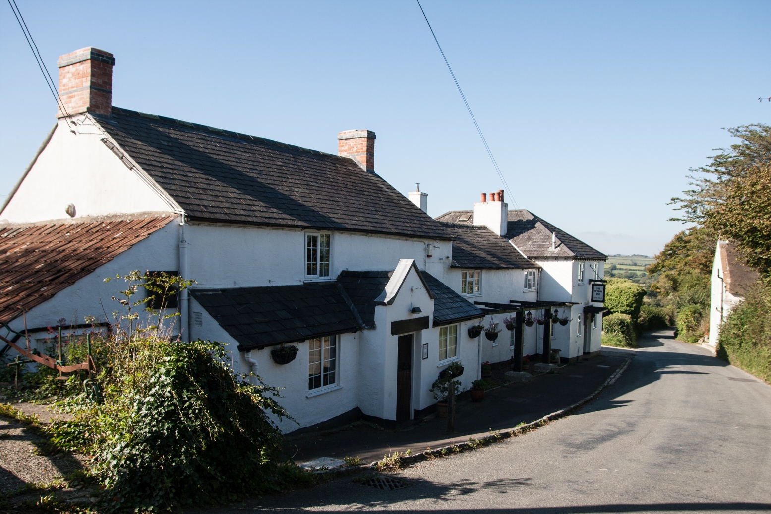
After a short downhill bit, it was an uphill climb to the Spyway Pub and several cars passed in the brief spell I was on the road. I was not the only non-car user on the road; a girl with a bike dismounted after freewheeling downhill to push her bike up the hill. She wasn't going much faster than me and as we neared the top of the hill I had to slow down a bit lest I caught up with her - and I wanted to avoid the awkward situation of not knowing whether to walk alongside her, say hello and walk past, say something witty (if possible) or simply say nothing at all. I agonised over this question whilst puffing my way up the hill and then didn't have to agonise over it any longer because she parked her bike at the pub and went in the back way. She presumably works there.
 |
| Spyway Pub - SY5293 |
In the many times I've visited this area, I don't recall having seen the Spyway Pub before, let alone go in! Today wasn't going to be my day either. I walked slightly past the pub and then turned left towards South Eggardon Farm. I immediately recognised the track; I had been down here before, but it looked so beautiful today. Autumn flora always takes me by surprise. Just when you think everything has finished for the year, autumn comes up trumps with some purple, violet flowers like scabious and knapweed and, my favourite, harebell.
 |
| Bee on Knapweed near South Eggardon Farm - SY5393 |
I was now getting my first views of Eggardon Hill, swathed today in sunshine.
 |
| Eggardon Hill from the south-west - SY5393 |
I was vaguely recalling a walk here with the Footloose group in the summer in blisteringly hot weather when I hadn't been able to fully appreciate the scenery.I disturbed some Moorhen as I walked past the pond at South Eggardon Farm.
 |
| Pond at South Eggardon Farm - SY5393 |
I wandered across an area of what would once have been extremely boggy land, heading north to North Eggardon Farm. I was walking now in T-shirt and trousers and was beginning to wish I'd put my shorts on and not brought my fleece and waterproof jacket. It was all extra weight and I never needed them once.
I turned to photograph the sunlight on the gate I'd just come through and then I was in a new gridsquare and headed towards North Eggardon Farm.
 |
| Gate between South and North Eggardon Farm - SY5393 |
 |
| North Eggardon Farm - SY5394 |
I promised myself a stop on Eggardon Hill. It wasn't quite lunch time and I was still worried that it looked like I'd got an awful long way to walk so thought I'd better not stop long. This is one of my favourite spots in Dorset though and today it was simply alive with the breath of the wind and butterflies alighting on yellow hawkbit, pirouetting and then flying off again. In particular abundance were the Small Coppers, which we'd hardly seen at all last year. They are such an arresting colour and I felt like I saw enough today to make up for the lack of them last year (well, maybe not quite!)
Even rarer than the Small Coppers, however, were the Clouded Yellow which danced on to the Eggardon stage in their sunshine yellow as if to say, "but look at me, look at me and catch me if you can." Because you simply can't. You sidewalk up the slopes of this ancient hillfort and watch your prey scaling ever higher with such ease and grace that it's best just to let them fly off unphotographed but for the moving image caught in your memory, which is often better than a still image anyway.
 |
| From North Eggardon Farm to Eggardon Hill - SY5394 |
I sat for a while taking in this mesmerising scene and drinking my cup of tea and just thinking how lucky I was to be there then and watching those butterflies that no-one else was watching and to breathe in that fresh air and feel so alive. A Wheatear alighted on a fence post to bid me farewell before taking its long autumn flight back to its wintering territory in North Africa.
 |
| Small Copper on Eggardon Hill - SY5394 |
 |
| Eggardon Hill, towards Pilsdon Pen and Lewesdon Hill - SY5394 |
 |
| Southern flanks of Eggardon Hill - SY5494 |
Reluctantly I got up and left the magic of this iron age hill fort, walking round its south-eastern contours to a field with a distant herd of cows (and a trigpoint). I have only ever photographed this trigpoint from the road before, and would like to get up close, but then, really, what is there to surprise me in a lump of concrete? Not a lot methinks! Perhaps time has moved on, or I have and it is no longer such an obsession. I would much rather be looking at natural beauty and spending time absorbing energy from things that are alive and moving than things which are static and rather dead. That's not to say a trigpoint doesn't make a nice object for a walk now and again.
So I crossed the road and then found a permissive path with more cows in. This path saved me a walk of all of several yards,but even that can be welcome at times.I was now turning north and walking down the road for what I thought would only be a little bit.
 |
| Turn off to Wynford Eagle - SY5494 |
A tractor in the field on my right was busy ploughing or something and the occasional car passed me. I walked quite fast, eager to get the road bit over and done with. There was not a lot of birdlife around, but the views all round were stunning. A herd of cows saw me approach and must have thought it was lunch time because they came running over to me hopefully. "Sorry girls, nothing for you," I said through the fence.
 |
| Herd of cows at Eggardon Hill - SY5494 |
I was also eager to get into the next new gridsquare and despite my determination not to photograph the road, that's exactly what I did do - Barrowland Lane to be precise. "I'll take a photograph of the road just in case I don't see anything else to photograph later on," I told myself. It's a method I've adopted on my walks ever since I've left taking a photograph to the last minute and then missing the opportunity because someone accosts me and I feel too embarrassed to say, "Excuse me, nice to meet you, but excuse me while I take a photograph of your house/driveway/field." It's better to have a photograph in the bag, so to speak, and then improve on it if you get another chance. I didn't on this occasion because the bridleway shown on the map did not materialise.
 |
| Barrowland Lane - SY5495 |
Conscious of the tractor close by and that I was almost certainly about to trespass on that farmer's land, I opened the gate which should have been a bridleway. There was a painted blue blob on the gatepost which may or may not have represented the blue arrow to indicate a bridleway. The gate took some opening, but worse was to follow; there was a curled roll of barbed wire across the path I wanted to take. I wandered down to the far end of the field to see if there was any other way out. Nope. Not feeling brave enough to crawl under the barbed wire and be accused of trespassing, I went back to the impossible gate and heaved it open and walked down the road, cursing myself for not having checked that this was still a valid right of way. (It is, I checked when I got back).
This meant a longer road walk, which is something I do not relish. I find it monotonous, especially when walking on my own. It's also annoying having to keep stepping off the road for passing traffic, not that there was a lot today.
Anyway, it was difficult to be annoyed for long today as the sun was shining and I was smiling for almost all the rest of my walk. Plus my diversion down the road meant nipping into another gridsquare, not a new one, but it boosted my tally for the day.
 |
| Footpath crossroads on Barrowland Lane - SY5596 |
It was here that I was turning left and I was relieved to see that this right of way at least was still there. I headed towards Barrowland Farm where another obstacle awaited me.
 |
| Barrowland Farm - SY5496 |
It seemed that the cows were locked in the yard for milking and my path went straight through them. There was no way I was going to attempt that. What to do instead? I took the bridleway heading left (which was the one I had wanted to be on in the first place on my approach to the farm) and then either ducked under electric fences or opened them via the hook method if available. I did this four times before I was on the bridleway I needed to be on heading north towards Powerstock Common where I intended to have lunch.
This bridleway runs alongside Barrowland Park and it was obvious that this used to be parkland. I took a photograph of some stark dead branches, looking rather like bones.
 |
| Barrowland Park - SY5496 |
 |
| Boney trees in Barrowland Park - SY5495 |
It was a sight uphill gradient to the entrance to Powerstock Common and I had to crawl through a rusty old gate in order to keep strictly to the footpath as shown on the map. In reality I could have done it a lot easier, but I didn't know that then and only do now because Paul and I went back and did this half of the walk again a couple of days later - there, that's how much I enjoyed it!
At last I was in Powerstock Common. Now for lunch!
 |
| Old sign upon entering Powerstock Common Nature Reserve - SY5496 |
 |
| Woodland in Powerstock Common - SY5496 |
I had never been in this part of the nature reserve before; we usually enter at the northern entrance. It is a beautiful and relatively infrequently visited reserve, which makes it even more appealing in my opinion.
When I found a nice open area, I plonked down with my mat, flask and lunch bag feeling so happy to be here and revelling in fresh air and solitude.
 |
| Powerstock Common - my lunch spot - SY5396 |
With almost seven miles behind me I was sure I'd broken the back of the walk, but I have so often miscalculated the miles, I thought I'd better not linger too long, so I set off again through dappled woodland where few footprints had fallen before mine.
 |
| Dappled woodland, Powerstock Common - SY5396 |
I emerged into permanent, unimproved pasture and walked towards Whetley Farm, looking back to Eggardon Hill, now south-east of me.
 |
| Permanent pasture, Powerstock Common - SY5396 |
 |
| Eggardon Hill from the north-west - SY5396 |
Whetley Farm had an interesting array of antlers displayed in its orchard garden.
 |
| Antlers at Whetley Farm - SY5396 |
I headed south-east past an attractive stone built cottage with its own bridge.
 |
| Cottage at Whetley Farm - SY5396 |
I was walking uphill now on a narrow single-track road and a couple of cars/trucks passed me in the third of a mile I was on the road. At King's Farm I turned right onto a footpath which led to a byway. I peeked through the hedge to get a view of King's Farm. It sits in an enviable location with windows on all sides, making the most of the incredible vista surrounding it.
 |
| King's Farm - SY5395 |
I was quite close again to Eggardon Hill, which I was almost going to circumnavigate during the course of my walk today. I couldn't resist taking more photographs of this iconic Dorset landmark.
 |
| Eggardon Hill from the north-west - SY5395 |
I passed Marsh Farm and joined a minor road. I was soon going to find out whether my walk would be extended or not. Part of the reason I had been unsure about the length of the walk was because I hadn't known whether it was possible to walk along this section of the disused railway line. Some sections between Maiden Newton and Loders are walkable and others aren't. We have walked most of the bits that are, but not this particular bit.
Just as I approached the railway bridge, a couple and a dog came out from the north side of the road. Had they been walking along the railway line? I asked them if they knew whether it was possible to walk to Loders along the railway line and they said it was, and that was the direction they were going in. I therefore then faced awkward situation number two of the day. Did I walk with them or linger over a photograph and avoid that situation? If I was going to walk along the railway line I has to turn off both east and west onto footpaths in order to photograph other squares that I would not otherwise get and that would just be plain embarrassing if I was walking with other people. But if they were walking the same pace as me, how would I avoid walking with them?
In the end I didn't need to worry too much as they walked really fast and by the time I had taken my requisite photo, they had disappeared into the distance, probably wondering what I was finding so fascinating about an old railway line!
 |
| Disused railway line south of Powerstock - SY5295 |
At the junction in gridsquares, I dipped into both SY5195 and SY5294. I knew the latter would be a brand new one, but I was not sure about SY5195. I decided I would wander 100 feet into the square, just to be on the safe side. How many times have I got back from a walk and realised I'd been within feet of a new gridsquare but hadn't realised it at the time? It turned out that SY5195 was not a new gridsquare, but it was a nice walk anyway!
 |
| Disused railway line near Mappercombe Manor - SY5195 |
 |
| Footpath to Spyway Road - SY5194 |
The countryside had donned its autumnal wardrobe; reds, oranges and bronzes were just beginning to shine through the green. There were loads of berries about, including bright red ropes of bryony.
 |
| Bryony- SY5295 |
I suddenly realised that I was nearing the end of my walk. Had I not been able to walk along the old railway line, I would have had to go through Nettlecombe and down past Mappercombe Manor, which would have added on a good mile to the length. We have walked past Mappercombe Manor before and commented on its position with outstanding views over the Dorset countryside.
 |
| Mappercombe Manor - SY5194 |
I slowed my pace as I approached Loders, feeling that the end had been too sudden.
 |
| Old railway line near Loders - SY5194 |
Just before the end, however, I took a wrong turn and veered away unknowingly from the railway line. Then I was determined I wasn't going to turn back. surely there was a gate out of this field and a way across the river (Asker)? After some to-ing and fro-ing I jumped across the river (OK, so it was a mere stream at this point) and I was back on the road and walked back under the railway tunnel to my car.
It had been a delightful walk, my first one of the autumn. I hope for many more.
Number of miles walked: 11
Number of new gridsquares: 7