After two days of being indoors watching the rain outside, we decided to risk the weather and go for a Sunday walk, somewhere local in case we got very wet.
After seeing a postcard of a tiny old church when we attended a Brown hairstreak egg survey in November last year, I had added a visit to Old St Cuthbert's Church in Oborne to my 'to do' list for this year. It's great when you start crossing off your 'to do' items so early in the new year (now all I've got left to concentrate on in the next 11 months is moving house, writing a book and seeing Great Bustard!) At least I've started with the most important thing!
We parked in Sherborne and set off after an unexpected conversation with our neighbouring car. Whilst his wife stood silently by, the well-dressed elderly gentleman chatted away about Scotland - how his brother used to take his girlfriend courting somewhere secluded, start seducing her by playing the bagpipes and then find themselves surrounded by a great throng of admiring listeners. She was obviously keener on the bagpipes than I am because she is now his wife! This all stemmed from the well-dressed gentleman asking us whether the car park was free on Sundays (We thought so, "yes, it is," we confirmed having read the sign next to our cars.)
We walked through the town northwards. Once in the Quarr Nature Reserve, we felt we had begun our walk proper. I had walked in this gridsquare before, so didn't need a photo for Geograph, which meant I could relax a little and indulge in my obsession with trees. Dull weather provides opportunities for close up photography, particularly abstracts and I began to see the tress in a new, almost human, light.
 |
| Inverted tree trunk detail - Quarr Nature Reserve - ST6317 |
 |
| Inverted tree trunk detail - Quarr Nature Reserve - ST6317 |
There were a few people out and, judging from the number of tell-tale poo bags and left poo piles on the wood floor, it was a popular place for dog walkers. We came across an elderly gentleman, gaunt and breathless with a big black Labrador. He was bent double and coughing. We encouraged him to sit down and rest and asked if he needed any help. He assured us he didn't. He'd make his way home after sitting down for a bit. He'd caught the 'flu from sharing a bottle of Christmas tipple. "Either that or from some old dear who insisted in giving me a New Year kiss," he smiled. Trying not to dwell on this image, I asked if he would like us to escort him home. "No, thank you," he gasped, "I only live down the lane." He then found his voice again to shout at his dog who apparently was muzzling some dog poo on the road.
We left him to recover, satisfied he was fit enough to stumble home and continued on our way. We walked up Quarr Lane to Sandford Orcas road. I had previously done a similar walk in February 2015, so had photos for a few of the gridsquares we would walk through today.
 |
| Quarr Lane - ST6318 |
 |
| Quarr Lane - ST6318 |
A couple of cars passed us as we walked up Sandford Orcas Road and Ambrose Hill, thinking of rice pudding of course!
 |
| Sandford Orcas Road and Ambrose Hill - ST6218 |
At the T-junction we turned off onto Clatcombe Lane towards Oborne. I was glad I had a much nicer photograph for this gridsquare taken in September 2015.
 |
| Clatcombe junction - ST6219 |
 |
| View from Patson Hill Lane, Sep 20515 - ST6219 |
We were heading towards the golf course now, still uphill. We passed Ambrose Lodge and turned left onto the golf course, taking our lives into our hands as, being a Sunday, the golf course was quite busy. We waited for a trio of golfers to tee off before venturing onto the golf course. Fortunately you don't have to linger long on the green - but long enough to hear a roar of "FORE!" I didn't know that's what he'd roared until Paul enlightened me later on after I'd shown myself up. "Perhaps that's someone got a hole in one," I suggested, mistaking a roar of warning for an exclamation of joy. "It means there's a ball coming this way," Paul laughed. He couldn't believe I'd not heard that expression before. Golf comes only just above inland revenue on my list of most boring subjects ever to discuss and there's very few golf courses on the moorlands of Scotland so why should I have heard of it? And what a stupid thing to shout. I much prefer "TIMBER!"
My official photograph for ST6319 was a blur so I'll have to go back (in spring next time). I took some photos of spider's webs and fungi though which worked out OK.
 |
| Jelly Ear Fungus and spider's web - ST6319 |
 |
| Spider's Web - ST6319 |
We waded through some pretty disgusting cow slurry near Holway Farm, adding an interesting pong to our already mud-encrusted boots. We were glad to emerge on hard tarmac again. A sign on the door of the mill made me giggle. 'Beware Children' was written in a font which made me think one really had to look over one's shoulder constantly lest some malevolent youngsters were 'out to get you'! It just shows you that it's not what is said but
how it is said that carries the most weight - even when those words are written and not vocal.
 |
| Holway Mill and Farm - ST6320 |
 |
| Malevolent kids on the loose! - ST6320 |
We;d now left the MacMillan Way and joined the Monarch's Way as we walked towards Stafford's Green where a sizeable pond is not marked on the map and we resisted the temptation to trespass and put two plastic chairs upright so we could sit on them for our tea break.
 |
| Stafford's Green - ST 6321 |
We were getting quite desperate for our mid morning break; it no longer being mid morning and our having walked nearly four miles already. I try to last for at least three miles before stopping for my first break unless there is very good reason to suggest otherwise - like there being a conveniently placed bench or church to visit. Today, however, it was incredibly muddy and there were no benches or churches on our route. I suggested hanging on till we reached Poyntington Down. "It's really pretty there," I reassured Paul.
We sat on our mats overlooking the pillow mounds - ancient rabbit warrens, smugly satisfied that we could identify all four of the mounds exactly as they were marked on the map. Ooooh, such satisfaction from trivia!
 |
| Pillow mounds on Poyntington Hill - ST6421 |
 |
| Sheep on Poyntington Hill - ST6421 |
After our late tea break/early lunch, we were revived and set off again, following the course of the River Yeo to the busy B3145, which we crossed and continued eastwards. We now had a hill to climb - Poyntington Hill - before we headed south.
 |
| Poyntington Hill - ST6521 |
On my previous, Febraury walk, I had descended the hill into the village of Poyntington in order to bag Higher Oborne trigpoint in ST6419. This time we were staying on the heights as far as Oborne. This part of the walk delighted in the name of Donkey Lane. Sadly I haven't been able to find anything out about the origin of this name.
 |
| Donkey Lane, Poyntington Hill - ST6520 |
We passed some more walkers just before heading down the hill.
 |
| Donkey Lane, Poyntington Hill - ST6519 |
A poignant message greeted us when we left Donkey Lane and joined the road leading to Oborne. No doubt written by someone who missed a loved one we wondered who R J was, man or woman, and whether they were still alive. Either way a romantic image of a couple wandering hand in hand along Donkey Lane filled my mind as we wandered hand in hand into the slumbering village of Oborne.
 |
| Sign on gate at end of Donkey Lane - ST6518 |
The roads form a letter 'H' in Oborne and the bit that joins the two roads is not marked as a footpath on the map, but a sign confirmed that we were able to walk down this slippy and badly lumpy track to join the western road.
 |
| Slippy road to the Grange, Oborne - ST6518 |
 |
| Mind the Ducks - a sign in Oborne Village - ST6518 |
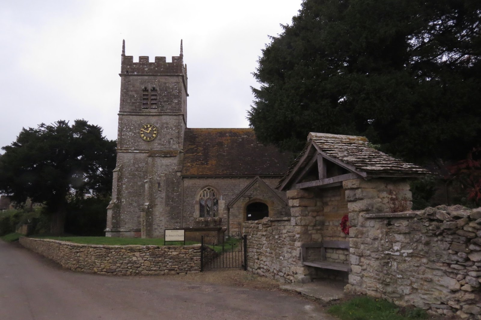
Oborne is a quaint Dorset village with lots of thatched cottages and a stream running by the side of the road. We walked along the road to join the roaring A30 and hopefully the tiny chapel of St Cuthbert which had been the incentive for this walk in the first place. "Now, I'm not absolutely sure that this is where it is," I confessed to Paul, whilst craning my neck to see over hedges and through trees for any sign of the building in question. I really hoped it would be just across the road from where we crossed as we didn't relish the thought of walking along a main 'A' road. "Is that it?" Paul asked, "There's a cross on its roof."
It was it and all was well. It was open and inviting for our early afternoon tea break and what a treat it was. We wondered why this tiniest of buildings did not qualify for the accolade of Dorset's smallest church (being pipped by St Edwold's in Stockwood). But read that this is in fact not a complete church. All that is left of the original building is the chancel, whereas the one in Stockwood is a complete church, measures just 30 foot by 12 foot. St Cuthbert's measures 21 foot by 12. After reading the following information though, I'm still in doubt as to which is the smallest. St Cuthbert's certainly looks very small and neat.
(ii) From Country Life September 11, 1942
THE SMALLEST CHURCH?
Sir, - I have often heard that the church at Oborne, near Sherborne, Dorset is the
second smallest in England. Recently you published a picture of that at Culbone, but
Oborne is smaller. It is 21ft. by 12ft., and was built in 1533 by the last Abbot of
Sherborne. It was a fowl-house in 1931, and has recently been restored by the Rector,
the Rev. Alan Williams, with the approval of the Society for the Preservation of
Ancient Buildings. It has a typical West Country wagon vault on oak rafters.
- F. R. WINSTONE, Bristol.
(iii) From The Western Gazette June 7, 1936.
ANCIENT CHANCEL RENOVATED
WORK OF ST. CUTHERT’S AT OBORNE
BISHOP AT THANKSGIVING SERVICE.
Upon the completion of the renovation of the interior of Old St Cuthbert’s chancel at
Oborne – the second smallest occasionally-used church in England – services of
worship and thanksgiving were held in it on Sunday.
(Extracts from
http://www.yeoheadpc.co.uk/History/The%20Ancient%20Chapel%20of%20St%20Cuthbert.pdf
 |
| Inside St Cuthbert's Church, Oborne - ST6517 |
 |
| Inside St Cuthbert's Church, Oborne - ST6517 |
 |
| The tiny St Cuthbert's Church, Oborne - ST6517 |
We sat in the boxed pew with our afternoon tea, saddened to learn that the original communion table had been stolen, but glad that the original mosaic floor had been incorporated into a sort of pillar by the western door.
 |
| Floor tiles in St Cuthbert's Church, Oborne - ST6517 |
We left the church and walked underneath the railway towards Sherborne Castle Estate.
 |
| Railway bridge - ST6517 |
We were in contourless territory, but definitely not mudless. We walked through a ploughed filed to Crackmore Wood, gathering enough mud beneath our boots to turn them into muddy 'snow boots'!
 |
| Our 'snow' boots after walking through the big ploughed field near Crackmore Wood- ST6617 |
We reached the wood's edge and entered Sherborne Castle Estate near Pinford Lodge.
 |
| Sherborne Castle Estate entrance at Pinford - ST6617 |
Disappointed not to have access to the attractive looking Pinford Bridge, we walked through Pinford Farm to cross the outflow from Sherborne Lake via a much more modest bridge.
 |
| Pinford Bridge - ST6616 |
More modest it might be, but we spied a Marsh Tit here, which is quite a rarity and a lovely sighting for the new year. It didn't stay long enough for a photograph, sadly, but the ancient trees beckoned me and I went off to photograph them on what remained a dull day (weatherwise)
 |
| Bowing low - Oak tree in Sherbonre Castle Estate - ST6616 |
 |
| Bowing low - Oak tree in Sherborne Castle Estate - ST6616 |
 |
| Skeletal tree in Sherborne Castle Estate - ST6616 |
There was one huge hollow tree which Paul could have fitted in if he'd wanted to!
 |
| Hollow tree in Sherborne Castle Estate - ST6616 |
I was now in familiar territory as far as gridsquares were concerned. We had walked in this estate at the end of last year, so we knew wee were near the end of our long walk today. It had been pleasant with lots of trees, birds (Little Egret, Green Woodpecker and Marsh Tit being the highlights), mud and gridsquares!
Number of new gridsquares: 6
Number of new birds for the year: 3
Number of miles walked: 12.1