I'd marked out what I thought was a 12.2 mile circular walk starting and finishing at Sherborne and Sunday was a good opportunity to try it out, the clocks having gone back an hour overnight and thus giving us an extra hour to walk. The day started misty so the vivid autumn colours were somewhat subdued, but by the afternoon the sun had come out and we were dazzled by the fiery colours of beeches, oaks, sycamore, hazel, horse chestnut and Spindle.
We parked at the playing fields car park and walked eastwards towards the Castle.
 |
| Sherborne Castle - ST6416 |
The new castle was built by Sir Walter Raleigh in 1594 and is said to be the only place where he truly felt at home. This might explain why his ghost is said to return to the Castle every year on the eve of the feast of St Michael (29th September) and of his execution at London in 1618 after his arrest and imprisonment in the Tower of London as a conspirator against King James I. His ghost is said to walk beneath the trees in the castle grounds before sitting on the stone seat named after him where he used to smoke the tobacco he was famed for introducing to England.
There is no entry to the Castle grounds from the south so we followed the footpath eastwards right along the southern edge of ST6516 and looked across to the Lake where fishermen were setting up for the day.
 |
| Track that runs south of Sherborne Castle, along the gridline of ST6516 |
We then climbed Jerusalem Hill, and I have been unable to find out the origin of this hill's name. Near the summit there is a boarded up lodge house.
 |
| Lodge at Jerusalem - ST6616 |
We walked through the woodland here, intrigued by the name of The Camp which we soon happened upon. Apparently the brick foundations here are the relics of a nissen hut field hospital,
built in 1943 by the Americans. After the war, like many other then abandoned camps, it was handed over by the MOD to the National Assistance Board for housing Displaced People, mostly families and relatives of Polish soldiers returning from Europe to be resettled by the Polish Resettlement Corps. The NAB purchased surplus NAAFI. furniture that was on site to furnish the empty huts with the basics; chairs, tables, cupboards, beds and bedding. The huts were divided in half with a door and windows at each end and housed two families in each hut. Conditions were very basic there was no running water in the huts and people had to use communal washing and toilet facilities, but for the first time since 1939 people found safety and some stability in their lives. The camp closed in 1955/56.
|
|
 |
Haydon Park Camp - once a field hospital and then a polish Resettlement Camp - ST6616
|
 |
| Massive Oak tree near Haydon Park Camp - ST6616 |
 |
| Weighbridge at Haydon Park Camp - ST6616 |
 |
| Honey Fungus near Haydon Park Camp |
Leaving the Camp, we exited Sherborne Castle Estate via another lodge, just cutting the corner of ST6615.
 |
| Lodge and southern entrance to Sherborne Castle Estate - ST6615 |
We made a slight diversion to visit what we thought was Haydon Church, but which we found out later has now been converted into offices. So that's why it was locked and explains the major new car park outside! There is an old cross in the small graveyard.
 |
| St Catherine's Church, Haydon - ST6715 |
 |
| Old cross in St Catherine's gravEyard - ST6715 |
We discussed the pros and cons of walking along the road leading north-east form here, as opposed to the footpath leading directly east, vis a vis, the road is quicker. It is also, obviously more dangerous, so we opted for the longer route via the footpath and Coach Hill Wood - which I thought sounded like a good haunting ground for another ghost. There is a little brick building in the corner of the field here, whose use we could not determine. Despite being marked as a footpath, the gate to this field is locked and the footpath sign has been removed. Undeterred, we climbed the gate and wandered up the hill.
 |
| Autumn colours from Haydon Hill - ST6815 |
 |
| Autumn colours from Haydon Hill - ST6815 |
We walked the whole length of ST6815 and entered ST6915, where we realised we could cut off a bit of distance by wandering across the field here.
 |
| Fields near Rue Lane - ST6815 |
We sat with a cup of tea in ST6816 at the only place convenient - a piece of concrete over a small brook here. The names Hussen Hanging and Muse Hill intrigued me, but I have not been able to find anything out about the origins of these names.
 |
| Footpath near Hussen Hanging - ST6816 |
We noticed lots of Spindle bushes here and Paul mused (on Muse Hill appropriately) that Spindle needs a thick hedge for its seedlings and a hedge will have to be 600 years old before Spindle occurs. Spindle gets its name from its use, being a hardwood, for knitting needles, skewers, pegs etc and spindles for spinning wool.
 |
| Spindle |
 |
| Goathill Lodge - ST6716 |
We walked up Goathill to join the road we would have been on if we had chosen to walk Haydn Hollow instead of the footpaths. The entrance to Hanover Wood has been lamely blocked by a piece of string, despite the footpath sign here. Maybe this was the work of some trick or treaters - there was evidence of Halloween being celebrated at the Crossroads at least.
 |
| Crossroads at Goathill - ST6716 |
October is a great month for fungi and I kept stopping to photograph the plethora of shapes, sizes and colours to be found in the various woodlands we walked through today.
 |
| Fungi in Hanover Woods |
 |
| Fungi in Hanover Woods |
 |
| Honey Fungus and slug in Hanover Woods |
For once I was not agonising over whether we were in a new gridsquare because we had temporarily crossed the border into Somerset - not that you'd know unless you kept checking the map; there are no border signs or demarcations to suggest as much.
"We'll be back in Dorset once we're through the woods," I announced to Paul as we slogged our way up yet another hill. We were also now in Purse Caundle CP and very close to the village of the same name where we decided to have an early lunch, having breakfasted early and being awake for an hour more than usual.
 |
| Back in Dorset - ST6817 |
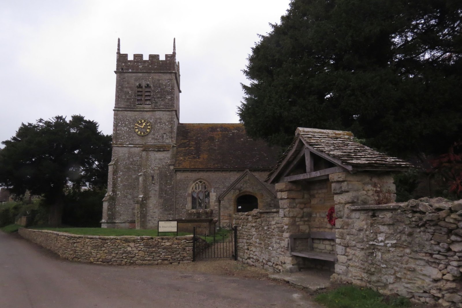
We sat by St Peter's Church with our lunch, hoping to accost anybody that passed by with the aim of gleaning information as to where we could procure the key for the church, which was locked. We were in luck; a family walked by and told us what we needed to know and then the lady in question appeared and I ran across the road to ask her. She was only too happy to open the church for us, saying she'd lock it again in ten minutes on her way back.
 |
| Alms Box, St Peter's Church, Purse Caundle - ST6917 |
 |
| Alms Box, St Peter's Church, Purse Caundle - ST6917 |
 |
| Interior of St Peter's Church, Purse Caundle - ST6917 |
 |
| St Peter's Church, Purse Caundle - ST6917 |
There was not a lot of interest in the church, so we left after a short visit and took a short diversion to view the Manor (said to be haunted), then retraced our steps and went on south-eastwards to Clayhanger.
 |
| Clayhanger - ST7016 |
There were some fast and furious vehicles along this narrow road and nowhere really to pull in - so this must be borne in mind for future visits.
Once off the road however, we were back in woodland, Plumley Wood to be precise, and walking along delightfully leaf-strewn paths in a myriad of colours.
 |
Walking through Plumley Wood - ST6916
|
 |
| Footpath near Woodrow Farm - ST6915 |
We emerged by a freshly sown field which we walked round instead of straight across and came out at Holt Lane.
 |
| Near Holt Lane - ST6914 |
At Holt Farm we turned left down Holt Hill and followed the road for a bit, before turning right onto Birch Copse (few Birch trees in sight, but lots of Hazel).
 |
| Holt Hill - ST6814 |
We left the road at New Lane and mused on what Old Lane would have looked like, given that this one seemed to be quite ancient and overgrown - albeit very pleasant.
 |
| New lane - ST6813 |
 |
| Footbridge and ford on New Lane - ST6813 |
We continued onto Marsh Court, where I remembered my previous visit here, where, upon crossing a stile out of the field we were just about to enter, I had got badly stung by Stinging Nettles. Fortunately the nettles had died back somewhat so were not so much of a problem this time.
 |
| Footpath near Marsh Court - ST6713 |
We were walking vaguely parallel to Writh Road and we did writhe a little when we saw the huge herd of cows in the field we wanted to walk through; there weren't just a few - there were hundreds! Well, maybe just 100, which is enough in a small field. We looked for an alternative exit and then realised actually there was a fence between us and the cows so we braved it instead. Which was all fine until we saw a gap in the electric fence between the cows and the path and the fence was hooked instead across our path. We unhooked it, walked towards the cows and hooked it in to prevent their access - the farmer probably wondered where they were come milking time, but otherwise they were for following us up the path in a disorderly fashion - no doubt about it!
 |
| Cows near Alweston - ST6714 |
We got a little confused about the footpaths here. Blind Lane was not immediately visible, so we ended up on Humpy Lane, just because I wanted to walk along it and then walked through the rather nondescript village of Alweston. Were we missing something?
 |
| Humpy Lane, Alweston - ST6614 |
We continued westwards, noticing a distinctive tower in our line of vision. We found out later this is the west tower of St Mary Magdalene Church, North Wootton, which dates from the early 15th Century.
 |
| Remains of St Mary Magdalene Church, North Wootton - ST6514 |
We had to turn quite a bit out of our way now as there is no direct route from North Wootton to Sherborne. We turned down Clotfurlong Lane (a furlong being 660 feet) and we were very relieved to discover that once again we could curtail our walk by quite a distance (about half a mile) by walking across a field instead of its whole length. This we did and managed to exit the field via a stile onto Green Lane, another delightful wooded footpath - and how spectacular the woods look at this time of year, especially now the sun had made an appearance.
 |
| Clotfurlong Lane - ST6514 |
 |
| Green Lane - ST6414 |
We were rather weary now, having realised that my 12.2 mile walk was going to be more like 14 miles by the time we'd got back, but we plodded on to the A3030, which we crossed and found another unmarked footpath by our third lodge of the day.
 |
| Green Lane - ST6415 |
We were now back into Sherborne Castle Estate, at its western extremity and walked down Gainsborough Hill and back to the car park, weary but satisfied.
 |
| Footpath through Gainsborough Hill and Wood - ST6415 |
Number of miles walked - 13.9
Number of gridsquares - 22 (a record I think)
Number of lodges - 3
Number of blocked foopaths - 3
Number of names with biblical references - 1


No comments:
Post a Comment