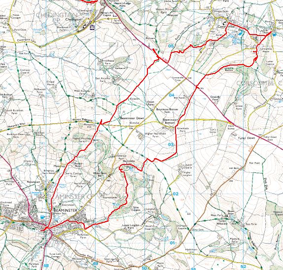
We had often driven through Corscombe and passed several footpath signs which looked intriguing. Well, they always do, don't they? You drive past them and think, 'One day we must walk along there to see where it goes,' and more often than not, you never make the effort. Well, my new quest to walk in every Dorset gridsquare, gave us an extra incentive this weekend. We would devise a walk round Corscombe.
This was swiftly done and we decided we'd park at Beaminster, for ease. Then we thought, 'Why not park at Corscombe? -It's nearer and cheaper!' So we did, after passing a princely parade of horses and their riders all set for their pretend hunt.
The forecast had been for a rather dull day, so our expectations were low, and, as is often the case with low expectations, they were exceeded abundantly. We walked south from the church for a little way (obviously taking a photo for the gridsquare), then headed west across Coombe Bottom. 'Coombe' means 'valley' in Somerset dialect (and probably other dialects too) and what a coombe it is. Illuminated by glorious winter sunshine and marred only by not-so-glorious winter mud, we trudged our way through verdant valleys, across undulating contour lines and allowed our minds to transform the scene into summer with accompanying lush green trees and fluttering butterflies.
 |
| Coombe Bottom |
 |
| Coombe Bottom |
 |
| Hedge-laying in Coombe Bottom |
 |
| Skeletal tree in Coombe Bottom |
Upon reaching the busy A356, we crossed straight over and walked down a track to the signposted B & B at Hill Farm. Here there were horses in the field which didn't bother us as much as the mud. I'm used to Islay's bog, but here the mud is so much dirtier and sticks stubbornly to your boots so that poor Paul spends a lot of time cleaning them afterwards.
I religiously attended to the map, taking photos of every gridsquare (most of which are too boring to upload here). Glad to be out of the muddy field, we crossed a minor road at Kitwhistle Farm and admired a beautiful thick hedge lain across a lush green field.
 |
| Beautiful hedge at Kitwhistle Farm |
We crossed the field with the escarpment (at least I think that's what you call this feature) - a steep patch of land with trees.
 |
| Escarpment near Kitwhistle Farm |
We diverged a little from the footpath due to the footpath sign being misleading, but quickly found our way back onto it and joined a track which led to what instantly became my No 1 Dorset view. unhindered by trees, buildings and anything else, the great Dorset vista lay southwards before our very eyes, with only a stile between us and the sea - the glistening blue sea. Okay, so I exaggerate a little, or rather quite a lot, but we could see the distant glistening sea and before it, Pilsdon Pen and Lewesdon Hill and some other diminutive heights all masquerading as mountains in this lowland county. Between us and the hills was deciduous woodland and, unbeknownst to us the palatial and oddly named Shatcombe Farm. We were grateful for the fact that this pretentious modern building was hidden from our view, although at the same time rather envious of
their view. The footpath is now diverted from crossing their property - not a problem for us - or so we thought until we started sinking in veritable quagmire. I've always been a little afraid of sinking in a woodland quagmire since seeing a scene in the film 'Lorna Doone' in which the baddie dies via that very means (at least I
think he's the baddie and I
think he dies).
 |
My favourite Dorset view so far - Lewesdon Hill and Pilsdon Pen in the distance
|
We squelched and squidged our way through this beautiful woodland of birch and Crack Willow, admiring a city of ant hills on the way and a secluded lake (I have difficulty not calling it a loch!).
 |
| Loch in Scite Coppice |
 |
Ant city in Scite Coppice
|
We sat by a wooden footbridge for our lunch and watched a gushing tributary of the River Brit wend its way into Beaminster. Later we crossed the River Brit and got deliciously muddy doing so, for the water had obviously recently come right over the bridge and flooded the surrounding area, the debris and sludge being very much in evidence and creating quite an obstacle to our walking progress.
 |
| Flooded footbridge near Beaminster |
Then we were suddenly in Beaminster, a town we have visited many times, but we had not been to St Mary's church before and I was anxious to visit this time after reading an intriguing 18th century ghost story associated with the church and town. I shall save the story for the time being as it's quite long, but really worth reading.
 |
| St Mary's Church, Beaminster - an intriguing ghost story is associated with this church. |
 |
Street in Beaminster
|
Now we had to make our way northwards, photographing grid squares on the way. The day had become rather dull and so had we as we plodded our way up the steep hill towards the Wessex Ridgeway again, past the thatched Meerhay Manor and horsey Higher Meerhay Farm. Once across the minor road, we were on Beaminster Down and read of an airstrip which had been partially constructed during the Second World War in a field nearby. Its construction had not been completed, however, before the end of the War and there is now no evidence of its existence - not even on Google Earth (or none that we could find!) We did pass a tumulus however, which made a convenient photo for gridsquare ST4903. (Dorset has a plethora of tumuli and barrows).
 |
| Tumulus on Beaminster Down |
A Stonechat on the bushes here was a bit of a surprise as we had passed lots of Gorse (Furze) and not seen any and now here it popped up in rather an unlikely place. Delightful little birds whether they're out of place or not. Dull weather lends itself well to abstract photos and we passed an ideal arboreal subject.
We were soon back at the busy A356 and crossed quickly to find a footpath through the field in which I wanted to bag my trig at Green Hill.
 |
| Green Hill trigpoint, looking towards Corscombe |
The footpath now wended its way down towards Corscombe and back to where we had started 11 miles earlier. A very worthwhile walk with splendid views over the Dorset countryside. One trigpoint and 14 gridsquares.


No comments:
Post a Comment